Antique maps catalogue
- All recent additions
-
Antique maps
- Polar maps
- World
-
Europe
- Europe Continent
- Belgium
- Belgium - Cities
- The Low Countries
- The Netherlands
- The Netherlands - Cities
- Luxembourg
- France
- France - Cities
- Germany
- Germany - Cities
- Austria
- Italy
- Italy - Cities
- Spain and Portugal
- Greece & Greek Islands
- Switzerland
- British Isles
- British Isles - Cities
- Northern Europe
- Central Europe
- Eastern Europe
- Southeastern Europe
- America
- Asia
- Africa
- Mediterranean Sea
- Australia
- Oceans
- Celestial Maps
- Curiosities
- Title Pages
- Books
- Medieval manuscripts
- Prints

Heightened in gold
The North Sea by P. Mortier. 1693
Carte de la Mer d'Allemagne ...
[Item number: 15485]

British Isles by Guillaume Delisle, published by Covens & Mortier. 1730
Les Isles Britanniques ou sont le Royaume D'Angleterre Tiré de...
[Item number: 25680]

Somerset, by J. Blaeu. 1645
Somersettensis Comitatus - Somerset Shire.
[Item number: 29770]

Wiltshire by J. Blaeu. 1645
Wiltonia sive Comitatus Wiltoniensis; Anglis Wil Shire.
[Item number: 29771]

Dorset, by J. Blaeu. 1645
Comitatus Dorcestria, sive Dorsettia; vulgo Anglice Dorset Shire
[Item number: 25750]

Isle of Wight, by J. Blaeu. 1645
Vectis Insula Anglice. The Isle of Wight.
[Item number: 25754]

British Isles by Nicolas Sanson, published by Giovanni de Rossi. 1677
L'Isole Britanniche ouero L'Inghilterra Divisa in sette Regni,...
[Item number: 32898]

Nottinghamshire by J. Blaeu. 1645
Comitatus Nottinghamiensis; Nottingham Shire.
[Item number: 25807]
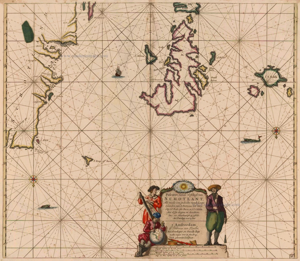
Scotland, with Lewis Island, by J. Van Keulen. Sea chart. 1697-1709
Pascaert, vande Westkust van Schotlant, als mede een Gedeelte...
[Item number: 12461]

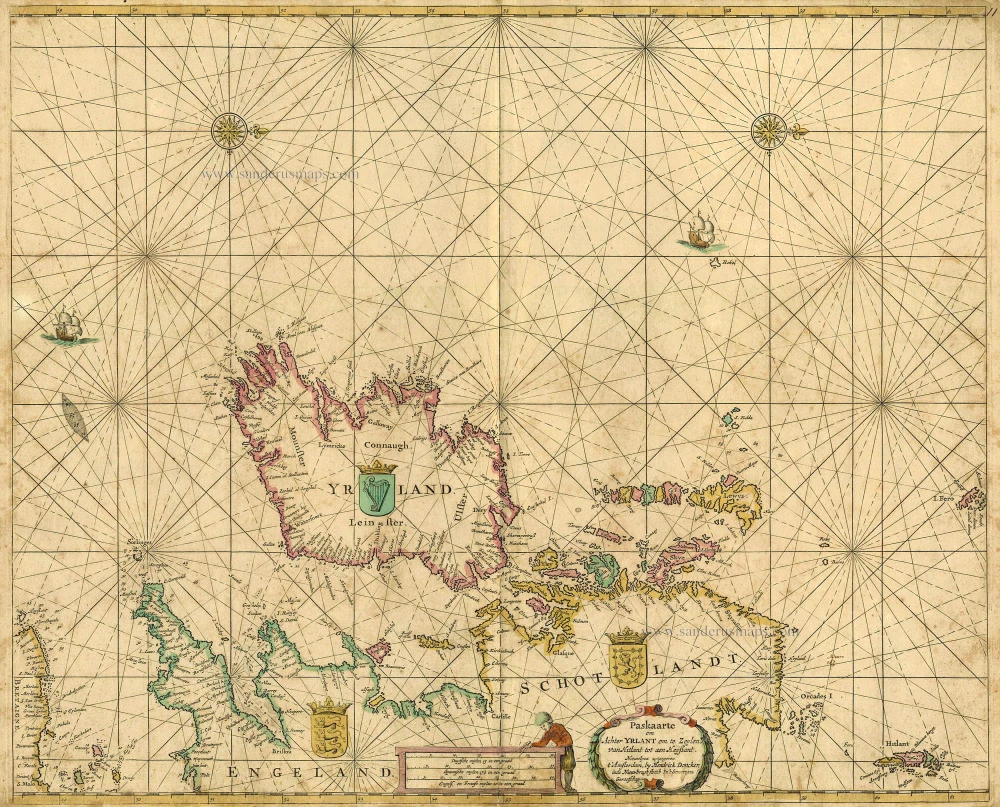
Ireland (Northwest), by Doncker H. 1686
Noord-west zyde van Yrlandt van C. de Hoorn to Slynhooft.
[Item number: 14899]
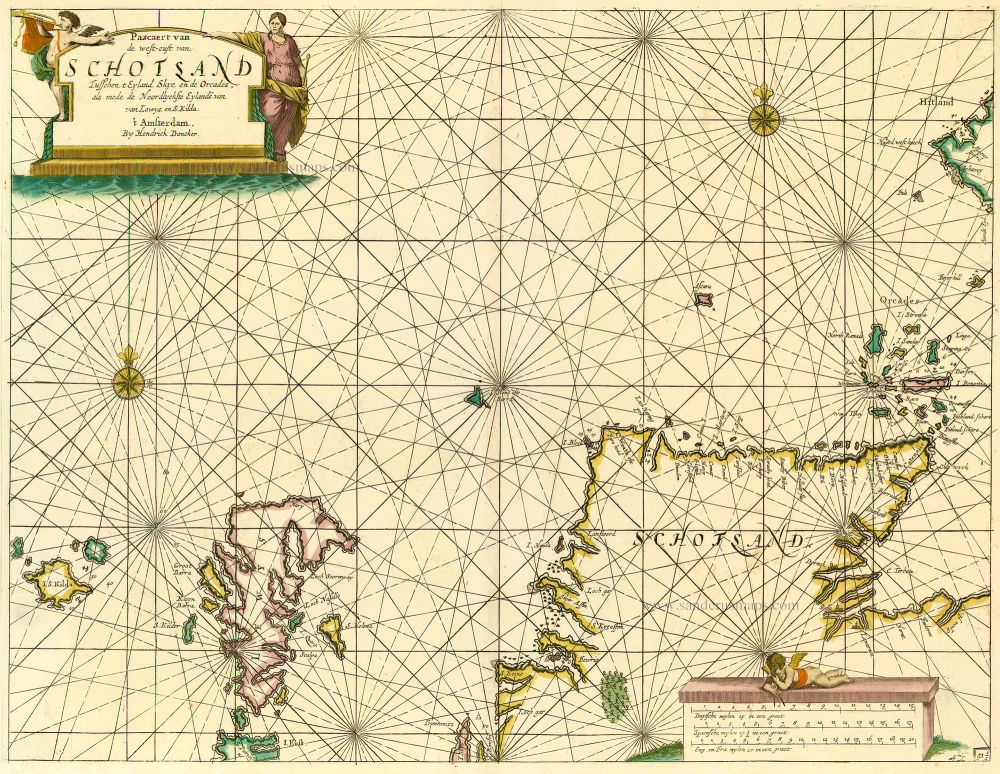
Scotland, by Doncker H. 1686
Pascaert van de Westcust van Schotland Tusschen t Eyland Kye en...
[Item number: 13737]
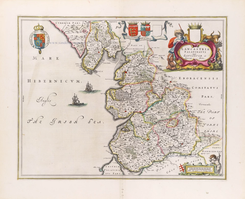
Lancashire, by Joan Blaeu. 1645
Lancastria Palatinatus Anglis Lancaster et Lancas Shire.
[Item number: 29783]

Hertfordshire & Middlesex, by Johannes Janssonius. 1647
Middelsexiae, cum Hertfordiae Comitatu; Midlesex & Hertford...
[Item number: 809]
British Isles, by Hendrik Doncker. 1665
Paskaarte om achter Yrlant om te Zeylen van Hitlant tot aen...
[Item number: 18567]

Wales, by Henricus Hondius. 1641
Cambriae Typus.
[Item number: 26245]

The British Isles, by Johannes Janssonius. 1641
Insularum Britannicarum Acurata Delineatio ex Geographicis...
[Item number: 26483]

Cornwall by Joan Blaeu. 1645
Cornubia sive Cornwallia.
[Item number: 33173]

Ireland (Southwest), by Doncker H. 1686
De West Custen van Yrlandt van Corckbeg tot Slynhooft
[Item number: 13767]

England and Wales by Visscher N. - Overton J. c. 1688
A New Mapp of the Kingdome of England, Representing the...
[Item number: 27517]

Scarce
England and Wales, by Cornelis Danckerts. 1696-1713
Accuratissima Angliae Regni et Walliae Principatus Descriptio...
[Item number: 32495]

Sussex, by Joan Blaeu. 1645
Suthsexia Vernacule Sussex.
[Item number: 32187]

The British Isles, by Pieter Goos. 1667
Paskaarte om Achter Yrlandt om te Zeylen van Hitlant tot aen...
[Item number: 19046]

Hampshire by J. Blaeu. 1645
Hantonia Sive Southantonensis Comitatus Vulgo Hantshire.
[Item number: 29772]

Wales, by Joan Blaeu. 1645
Wallia Principatus vulgo Wales.
[Item number: 33047]
new

Ireland, by Doncker H. 1686
De Noord-Oost zyde van Yerlandt van Caap de Hoorn-hout tot...
[Item number: 13644]
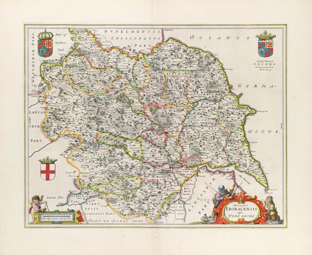
Yorkshire by Joan Blaeu. 1645
Ducatus Eboracensis Anglice York Shire.
[Item number: 29778]

British Isles by Hubert Jaillot, published by Reinier and Josua Ottens. 1730-45
Les Isles Britanniques; qui contiennent les Royaumes...
[Item number: 28747]

Bretagne and the Channel, by Van Keulen Johannes. 1697-1709
Pas-kaert vande Canael, Tusschen Engelandt en Vrancryck...
[Item number: 5406]

Sea chart
Normandy by Van Keulen Johannes. 1697-1709
Pascaert van de Canael Tusschen Engelandt en Vrancryck, van...
[Item number: 13639]
![Nieuwe Zeekaart van t' Eerste Gedeelte van t' Canaal Tusschen Engeland en Vrankrijk. [Title also in French, English, Spanish, and Italian]](https://sanderusmaps.com/assets/IMG/webp/m31427.webp)
Sea chart of the Channel by Gerard van Keulen. 1704
Nieuwe Zeekaart van t' Eerste Gedeelte van t' Canaal Tusschen...
[Item number: 31427]

Channel, by Pierre Mortier. c. 1705
Carte de la Manche.
[Item number: 28001]

North Yorkshire, by Joan Blaeu. 1645
Ducatus Eboracensis Pars Borealis; The Northriding of Yorke...
[Item number: 29780]
![Parte Settentrionale del Regno D'Inghilterra. [in set with:] Parte Meridionale del Regno D'Inghilterra.](https://sanderusmaps.com/assets/IMG/webp/m28662.webp)
England by Vincenzo Coronelli. 1696
Parte Settentrionale del Regno D'Inghilterra. [in set with:]...
[Item number: 28662]
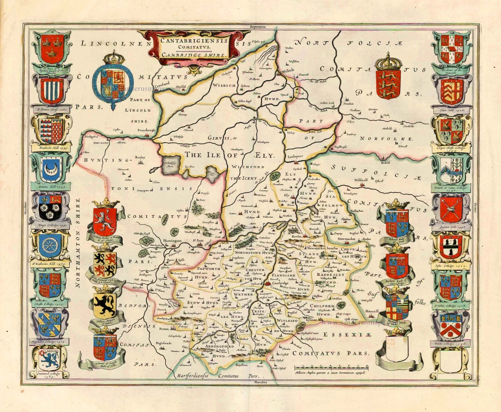
Cambridgeshire, by Joan Blaeu. 1645
Cantabrigiensis Comitatus; Cambridge Shire.
[Item number: 27571]

British Isles, by Van Keulen Johannes. 1697-1709
Paskaart van 't Canaal Engelandt Schotlandt en Yrland
[Item number: 5817]

British Isles, by H. Jaillot c. 1705
Les Isles Britanniques; qui Contiennent les Royaumes...
[Item number: 27772]