www.sanderusmaps.com
Sanderus
Antique maps & books
  • Home
  • About us
  • Contact us
  • References
  • Our catalogue
  • 0

Advanced search

x
RESET

Search

Advanced search

Antique maps catalogue

Antique maps / Europe / The Netherlands - Cities
open categories
  • All recent additions
  • Antique maps
    • Polar maps
    • World
    • Europe
      • Europe Continent
      • Belgium
      • Belgium - Cities
      • The Low Countries
      • The Netherlands
      • The Netherlands - Cities
      • Luxembourg
      • France
      • France - Cities
      • Germany
      • Germany - Cities
      • Austria
      • Italy
      • Italy - Cities
      • Spain and Portugal
      • Greece & Greek Islands
      • Switzerland
      • British Isles
      • British Isles - Cities
      • Northern Europe
      • Central Europe
      • Eastern Europe
      • Southeastern Europe
    • America
      • The Americas
      • North America
      • Central America
      • West Indies
      • South America
    • Asia
      • Asia
      • Central Asia
      • China
      • Holy Land
      • India - Ceylon
      • Japan
      • Middle East
      • Southeast Asia
      • Turkey - Cyprus
    • Africa
    • Mediterranean Sea
    • Australia
    • Oceans
    • Celestial Maps
    • Curiosities
    • Title Pages
  • Books
    • Atlases
    • Bibles
    • Books with Maps
    • Botany
    • Classics - Antiquity
    • History
    • Incunabula
    • Medicine
    • Miscellany
    • Natural History
    • Scientific Books
    • Travel Books
  • Medieval manuscripts
    • Antiphonary Leaf
    • Miniature
    • Text Leaf
  • Prints
    • Birds Barraband
    • Birds Nozeman
    • de Bry
    • Fish Bloch
    • Flowers Sweert/De Bry
    • Flowers Weinman
    • Fruits
    • Natural History
    • Hartmann Schedel - Liber Chronicarum
    • Master Prints
    • David Teniers
    • Naval Views - Ships
    • Vernet, C.&H. - Equestrian aquatints
    • Pluvinel - Equestrian Art
    • Angelo, D. M. T. - Fencing

Antique maps / Europe / The Netherlands - Cities
Showing 217 - 219 of 219 products
  • SORT BY
  • Title
  • Mapmaker
  • Price ↑ ↓
  • RESET
  • ‹ Previous
  • 1
  • 2
  • 3
  • 4
  • 5
  • 6
  • 7
  • › Next
Vraye et naturelle Carte topographique de la ville de Boisleduc, assiegeé par l'ennemy, et mutinez, le 18. d'Aoust l'an 1603: Ensemble le Camp de son Altesse ser.me l'Archiduc Albert, y campe le 21 dudict moys, soubs la conduite de Monseigneur ...

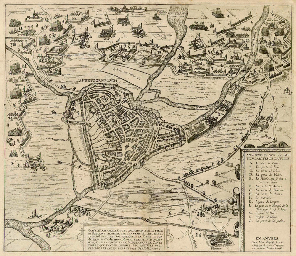
Extremely rare and important plan
's Hertogenbosch by J.B. Vrientius. c. 1603
Vraye et naturelle Carte topographique de la ville de Boisleduc,...
[Item number: 22488]

€3200  ($3648 / £2752)
Amstelodami Veteris et Novissimi delineatio per Jacobum de la Feuille

Spectacular and rare plan!
Amsterdam by Johannes de Ram, published by Jacob de la Feuille and Gerard van Keulen. c. 1710
Amstelodami Veteris et Novissimi delineatio per Jacobum de la...
[Item number: 32702]

€3500  ($3990 / £3010)
CVRRVS VELIFERI ILLVSTRISSIMI PRINCIPIS MAVRITII VOLITANTES DVABVS HORIS SCHEVERINA A PETTEMVM AD QVATVORDECIM MILLIARIA HOLLANDICA, QVAE SINGVLA IVSTAE HORAE EXCEDVNT

Very rare and spectacular plate
The Land-Yacht of 1603, by Willem van Swanenburg after Jacques de Gheyn II. 1652
CVRRVS VELIFERI ILLVSTRISSIMI PRINCIPIS MAVRITII VOLITANTES...
[Item number: 32833]

€22000  ($25080 / £18920)
  • ‹ Previous
  • 1
  • 2
  • 3
  • 4
  • 5
  • 6
  • 7
  • › Next

Contact us

Sanderusmaps
Nederkouter 32 - 9000 Ghent - Belgium
 +32 9 223 35 90
sanderus@sanderusmaps.com

Antique maps catalogue

  • All recent additions
  • Antique maps
  • Books
  • Medieval manuscripts
  • Prints

copyright © Sanderus 2026    About us -  Terms & conditions -  Privacy policy  -  Edit Cookie Settings

launched by Major Tom
www.sanderusmaps.com