Antique maps catalogue
- All recent additions
-
Antique maps
- Polar maps
- World
-
Europe
- Europe Continent
- Belgium
- Belgium - Cities
- The Low Countries
- The Netherlands
- The Netherlands - Cities
- Luxembourg
- France
- France - Cities
- Germany
- Germany - Cities
- Austria
- Italy
- Italy - Cities
- Spain and Portugal
- Greece & Greek Islands
- Switzerland
- British Isles
- British Isles - Cities
- Northern Europe
- Central Europe
- Eastern Europe
- Southeastern Europe
- America
- Asia
- Africa
- Mediterranean Sea
- Australia
- Oceans
- Celestial Maps
- Curiosities
- Title Pages
- Books
- Medieval manuscripts
- Prints

Southern India, by François Valentyn (Valentijn). 1724-26
Nieuwe kaart van Choromandel ende Malabar.
[Item number: 26896]

Southern India, by Z. Châtelain. 1719
Carte Nouvelle des Terres de Cucan, de Canara, de Malabar, de...
[Item number: 29378]
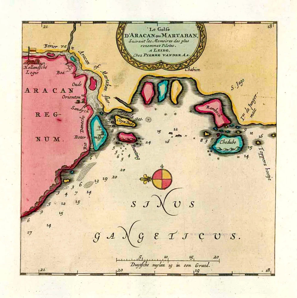
The Gulf of Martaban, by Pieter van der Aa. 1713
Le Golfe D'Aracan ou Martaban.
[Item number: 26106]
![Anfa, quibusdam Anaffa [on sheet with] Azaamurum [and] Diu [and] Goa.](https://sanderusmaps.com/assets/IMG/webp/m28048.webp)
Casablanca - Azimur - Diu - Goa, by Georg Braun & Frans Hogenberg. 1574
Anfa, quibusdam Anaffa [on sheet with] Azaamurum [and] Diu [and]...
[Item number: 28048]

Galle (Ceylon - Sri Lanka) ,by François Valentyn (Valentijn). 1724-26
Punto de Galle.
[Item number: 26902]

Ceylon (Sri Lanka), by Zacharias Châtelain. 1719
Nouvelle Carte de L'Ile de Ceylon, avec des Remarques...
[Item number: 29360]

Surat (India), by François Valentyn (Valentijn). 1726
De rivier van Suratta.
[Item number: 27940]

India, by Giovanni Magini 1597
Tabula Asiae XI.
[Item number: 26522]

Sri Lanka (Ceylon) - Trincomalee Bay by François Valentyn (Valentijn). 1724-26
Baay van Tricoen Male.
[Item number: 28627]

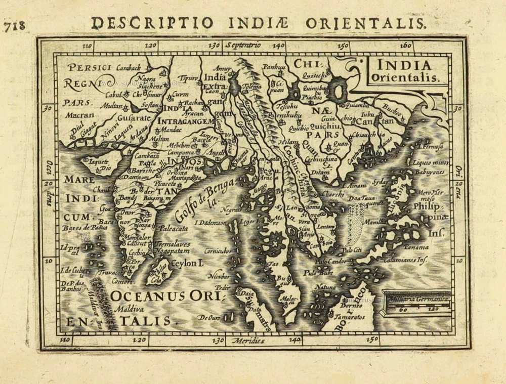
Southeast Asia, by G. Mercator - J. Hondius (small) 1607
India Orientalis.
[Item number: 25186]

South India and Ceylon by Barent Langenes & Cornelis Claesz c. 1600
Narsinga et Ceylon.
[Item number: 26999]

India - Bengal by Petrus Bertius, published by Jodocus Hondius II. 1618
Bengala.
[Item number: 32148]
East Indies by Petrus Bertius. 1616
India Orientalis.
[Item number: 28162]
![Taprobana. - [Above map :] Descrittione del l'Isola di Taprobana.](https://sanderusmaps.com/assets/IMG/webp/m29808.webp)
Ceylon (Sri Lanka) by Tommaso Porcacchi. 1590
Taprobana. - [Above map :] Descrittione del l'Isola di Taprobana.
[Item number: 29808]

India - Cambay by Petrus Bertius, published by Jodocus Hondius II. 1618
Cambaia
[Item number: 32145]

India - Malabar by Petrus Bertius, published by Jodocus Hondius II. 1618
Malabar.
[Item number: 32146]
![[Map of the Maldives] [and] Ceylon I.](https://sanderusmaps.com/assets/IMG/webp/m32170.webp)
Maldives and Ceylon, by Petrus Bertius 1618
[Map of the Maldives] [and] Ceylon I.
[Item number: 32170]
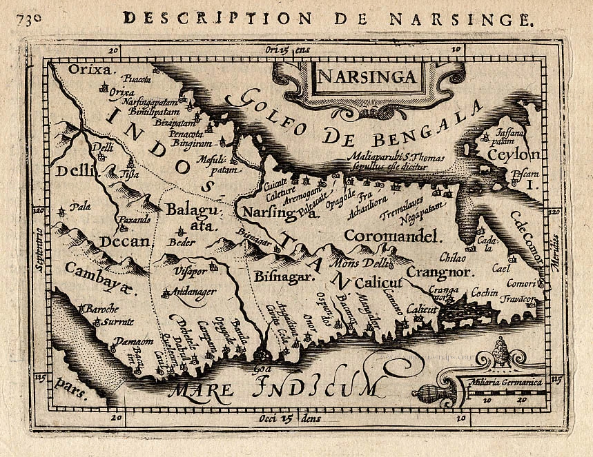
Narsinga, by P. Bertius. 1618
Narsinga.
[Item number: 18299]

Malabar by Barent Langenes & Cornelis Claesz c. 1600
Malabar.
[Item number: 26997]

The Gulf of Bengal, by O.J. Boucher. 1787
Carte du Golf de de Bengale, ...
[Item number: 26775]

Bengal, by Barent Langenes & Cornelis Claesz. c. 1600
Bengala.
[Item number: 27001]