Our catalogue catalogue
- All recent additions
-
Antique maps
- Polar maps
- World
-
Europe
- Europe Continent
- Belgium
- Belgium - Cities
- The Low Countries
- The Netherlands
- The Netherlands - Cities
- Luxembourg
- France
- France - Cities
- Germany
- Germany - Cities
- Austria
- Italy
- Italy - Cities
- Spain and Portugal
- Greece & Greek Islands
- Switzerland
- British Isles
- British Isles - Cities
- Northern Europe
- Central Europe
- Eastern Europe
- Southeastern Europe
- America
- Asia
- Africa
- Mediterranean Sea
- Australia
- Oceans
- Celestial Maps
- Curiosities
- Title Pages
- Books
- Medieval manuscripts
- Prints

Probably the most attractive map of the Roman Empire
Roman Empire by Ortelius Abraham 1601
Romani Imperii Imago.
[Item number: 32934]
new
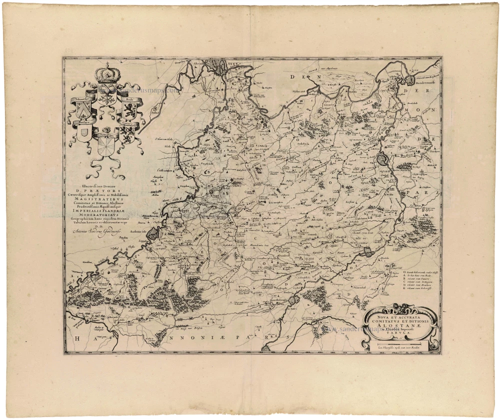
Aalst (Graafschap en Kasselrij) - Melle - Balegem, door Antonius Sanderus 1644 (= first edition)
Nova et accurata Comitatus et ditionis Alostanae
[Item number: 32986]
new

Aalst - St.-Maartenskerk, door Antonius Sanderus 1644 (= first edition)
Ecclesia Collegiata Sti Martini, Alosti.
[Item number: 32987]
new
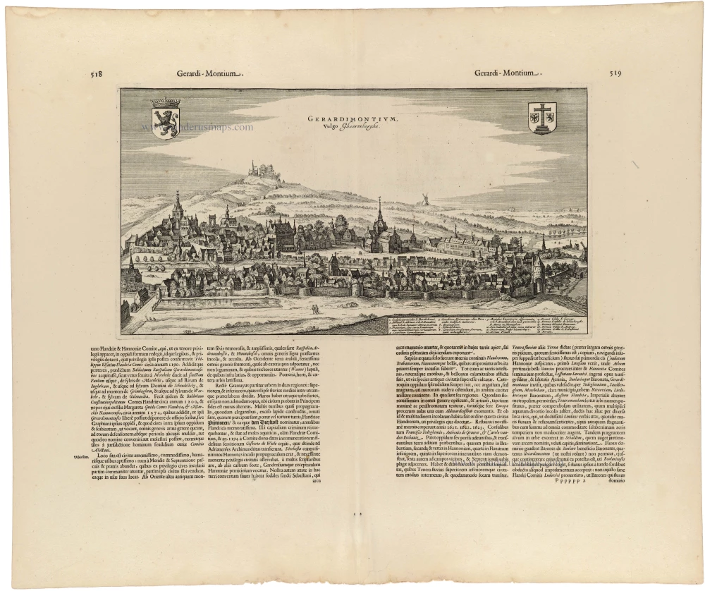
Geraardsbergen, by Antonius Sanderus. 1644 (= first edition)
Gerardimontium Vulgo Gheertsberghe.
[Item number: 32962]
new

Lo-Reninge by Antonius Sanderus. 1644 (= first edition)
Loo - Opidum et Abbatia S. Petri Loensis ordinis Canonicorum...
[Item number: 32998]
new
![Watou [verso:] Praetorium D. Adriani vander Burcht Toparchi de Elverdinge in Cast. Furnensi.](https://sanderusmaps.com/assets/WEBP/m32999.webp)
Poperinge - Watou / Ieper - Elverdinge by Antonius Sanderus. 1644 (= first edition)
Watou [verso:] Praetorium D. Adriani vander Burcht Toparchi de...
[Item number: 32999]
new

Veurne (Kasselrij) by Antonius Sanderus. 1644 (= first edition)
Nova et Exacta Castellaniae Furnensis Tabula Geographica, Vulgo...
[Item number: 33006]
new

Beautiful colouring
Kortrijk by Joan Blaeu. 1652
Cortracum, vulgo Cortryck, Gallice Courtray.
[Item number: 32948]
new
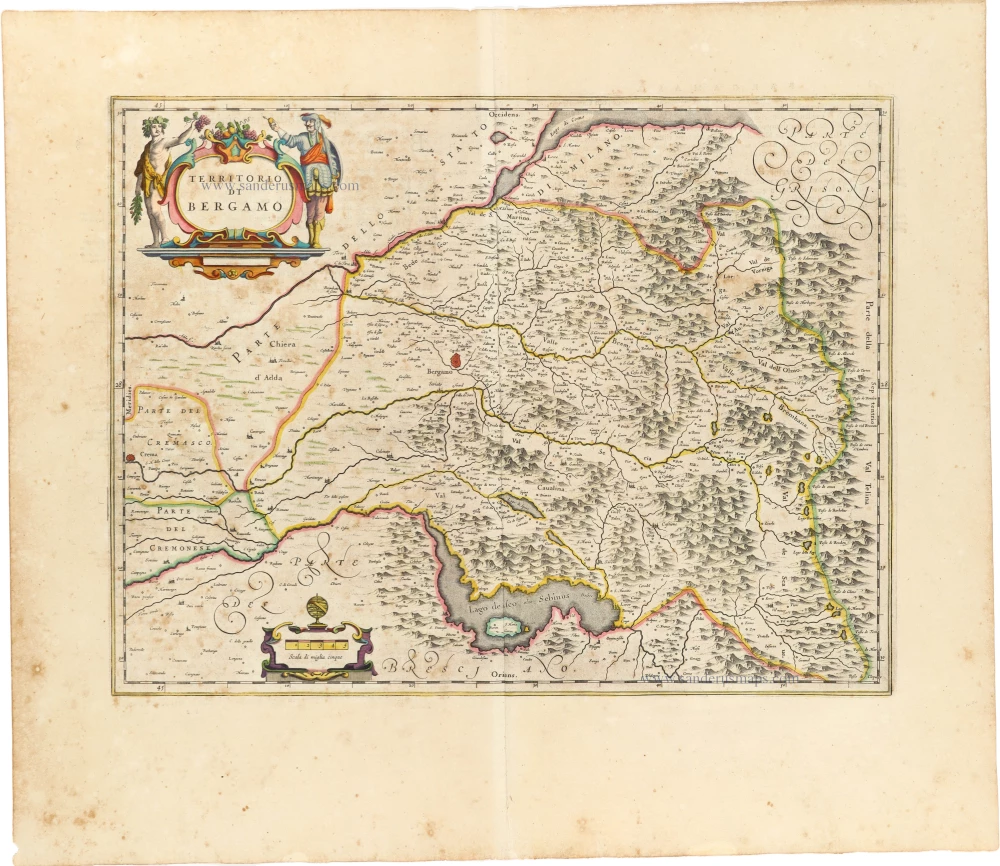
Bergamo, by Joan Blaeu. 1650
Territorio di Bergamo.
[Item number: 32977]
new

Den Haag, by Joan Blaeu. 1652
Haga Comitis Vulgo 'S Graven-Hage.
[Item number: 32922]
new
Only in the Atlas Maior
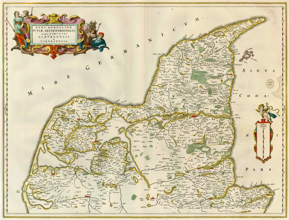
Jylland (South, Northern part) by Joan Blaeu. 1664
Pars Borealior Iutiae Septentrionalis, in qua Dioeceses...
[Item number: 15979]
new

Orvieto, by Willem & Joan Blaeu. 1640
Territorio di Orvieto.
[Item number: 28156]
new

Only in the Atlas Maior. Scarce
Ven by Joan Blaeu (Hven) 1662
Insula Huaena, sive Venusia.
[Item number: 32892]
new
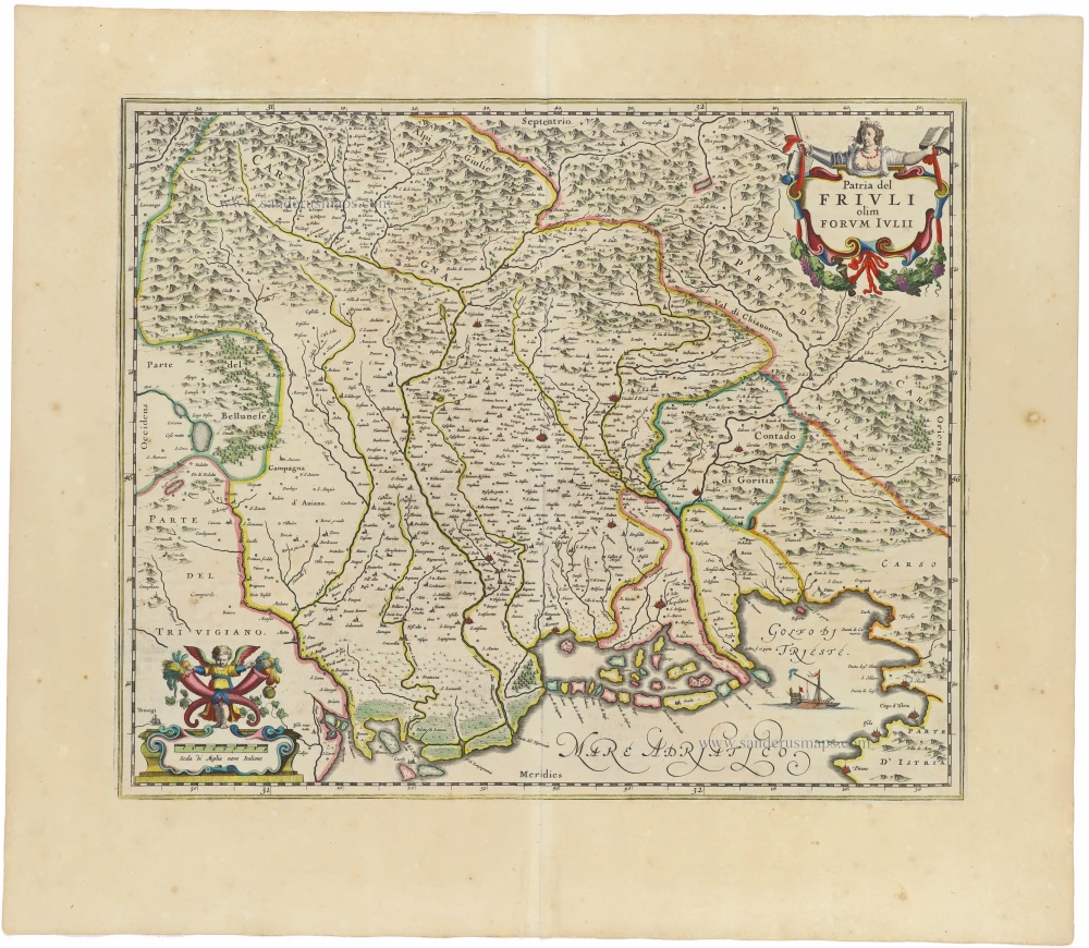
Friuli, by Joan Blaeu 1650
Patria del Friuli olim Forum Iulii.
[Item number: 32976]
new
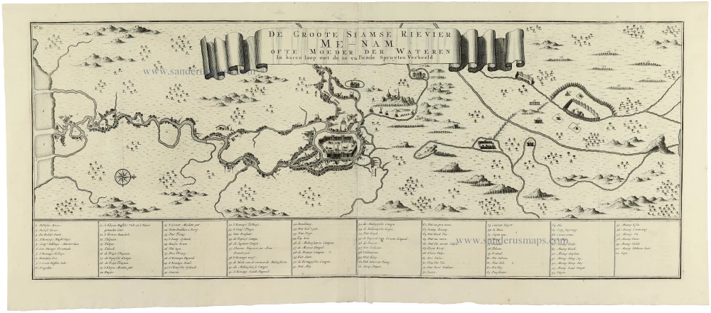
One of the most remarkable maps of the Siamese Kingdom
Thailand - Chao Phraya River Valley, by François Valentyn. 1724-26
De Groote Siamse Rievier Me-Nam ofte Moeder der Wateren In haren...
[Item number: 32935]
new
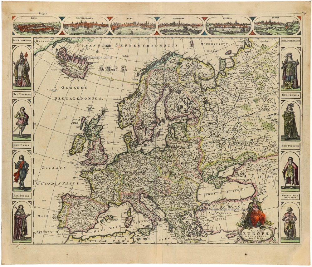
Scarce
Europe by Frederick de Wit 1689-90
Nova Europa Descriptio.
[Item number: 32974]
new
![Helsheborch [on sheet with] Lunden [and] Elbogen [and] Landeskron.](https://sanderusmaps.com/assets/WEBP/m32923.webp)
Malmö, Helsingborg, Lund, Landskrona, by Georg Braun & Frans Hogenberg 1623
Helsheborch [on sheet with] Lunden [and] Elbogen [and]...
[Item number: 32923]
new

First edition
Canterbury, by Georg Braun and Frans Hogenberg. 1588
Cantuarbury - Cantuaria Urbs ferrilis simae Angliae celebris...
[Item number: 32924]
new
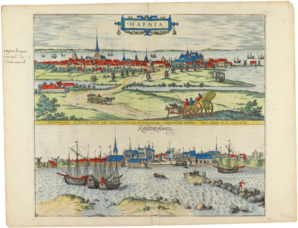
First edition
Copenhagen, by Georg Braun and Frans Hogenberg. 1588
Hafnia vulgo Kopenhagen.
[Item number: 32931]
new

Ost-Friesland by Gerard de Jode 1593
Frisiae Orientalis nova et exacta descriptio
[Item number: 32893]
new

Lithuania, by Gerard Mercator. 1630
Lithuania.
[Item number: 32925]
new

Europe by Gerard Mercator. 1613
Europa, ad Magnae Europae Gerardi Mercatoris P. Imitationem,...
[Item number: 32928]
new

One of the earliest charts of the Strait
Straits of Magellan, by Jodocus Hondius. 1630
Exquisita & magno aliquot mensium periculo lustrata et iam...
[Item number: 32929]
new

Persia by Henricus Hondius 1641
Persici vel Sophorum Regni Typus.
[Item number: 32932]
new
![Landgraviatus Alsatiae tam Superioris quam Inferi[oris] cum utroque Marchionatu Badensi ut et tractu Herciniae Silvae ac Ditione quatuor Urbium Silvestr[ium].](https://sanderusmaps.com/assets/WEBP/m32926.webp)
Alsace - Baden, by J.B. Homann. c. 1720
Landgraviatus Alsatiae tam Superioris quam Inferi[oris] cum...
[Item number: 32926]
new

Archbishopric and Electorate of Cologne, including the Duchies of Jülich and Berg, as well as the County of Meurs, by J.B. Homann. c. 1720
Archiepiscopatus et Electoratus Coloniensis ut et Duvatuum...
[Item number: 32927]
new

Rare and important sea chart
Ireland by Joannes Van Loon. 1666
Pas-caerte van Yrland, met Alle Zee-custen, Havenen,...
[Item number: 32978]
new
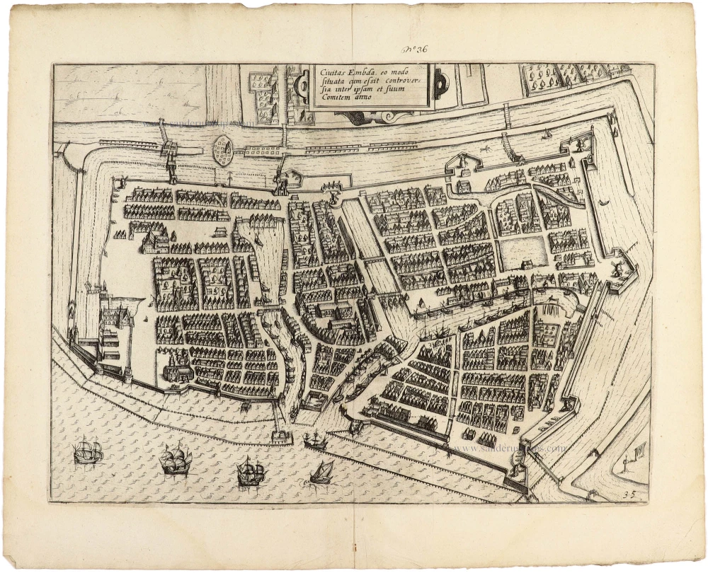
Emden, by Ludovicus Guicciardini. 1612
Civitas Embda, eo modo situata cum essit controversia inter...
[Item number: 32950]
new
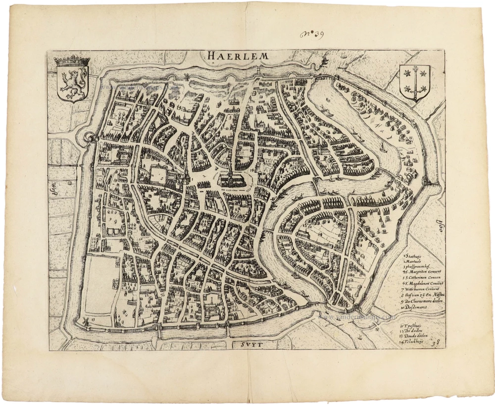
Haarlem, by Ludovicus Guicciardini. 1612
Haerlem.
[Item number: 32951]
new
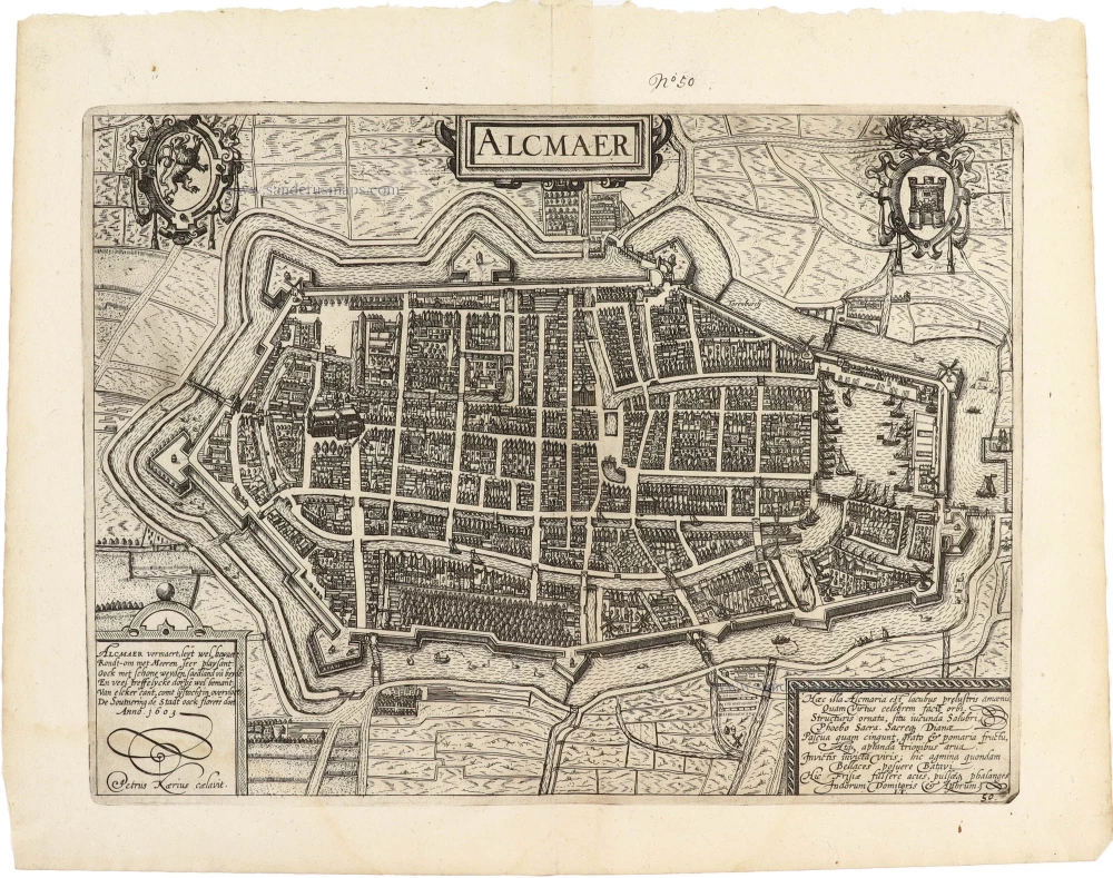
Alkmaar by Lodovico Guicciardini 1612
Alcmaer.
[Item number: 32980]
new
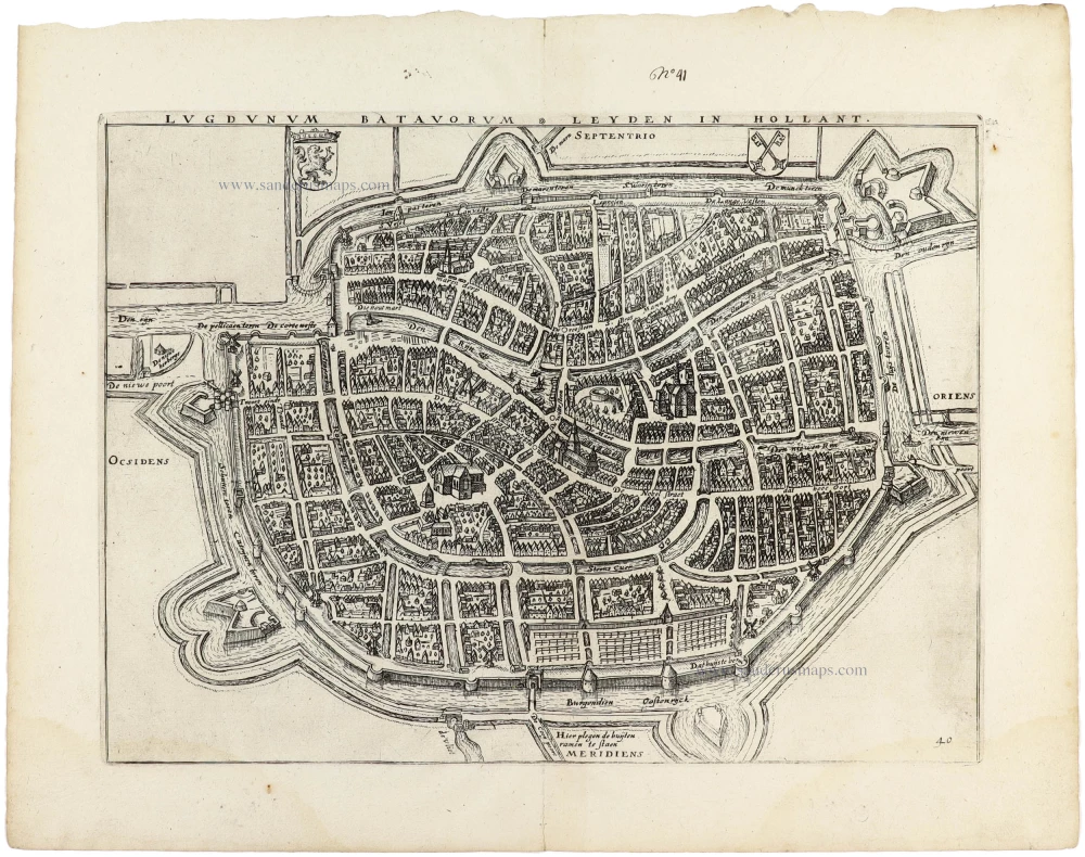
Leiden, by Ludovicus Guicciardini. 1612
Lugdunum Batavorum * Leyden in Hollant.
[Item number: 32952]
new

Gorinchem by Lodovico Guicciardini. 1612
Gorchum
[Item number: 32981]
new
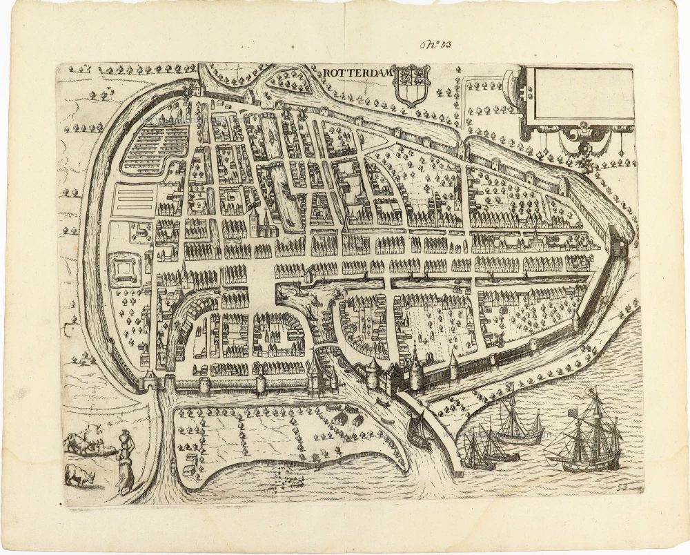
Rotterdam by Guicciardini Lodovico 1612
Rotterdam.
[Item number: 32982]
new
![Civitas Mons Geertrudan[us] sicuti erat dum occuparet' ab excelent: sua Mauritio de Naßou.](https://sanderusmaps.com/assets/WEBP/m32983.webp)
Geertruidenberg by Guicciardini Lodovico 1612
Civitas Mons Geertrudan[us] sicuti erat dum occuparet' ab...
[Item number: 32983]
new
![Graven Hage, t'Hof van Holla[n]t.](https://sanderusmaps.com/assets/WEBP/m32984.webp)
Den Haag by Guicciardini Lodovico 1612
Graven Hage, t'Hof van Holla[n]t.
[Item number: 32984]
new

Utrecht by Guicciardini Lodovico 1612
Trajectum
[Item number: 32989]
new