Antique maps catalogue
- All recent additions
-
Antique maps
- Polar maps
- World
-
Europe
- Europe Continent
- Belgium
- Belgium - Cities
- The Low Countries
- The Netherlands
- The Netherlands - Cities
- Luxembourg
- France
- France - Cities
- Germany
- Germany - Cities
- Austria
- Italy
- Italy - Cities
- Spain and Portugal
- Greece & Greek Islands
- Switzerland
- British Isles
- British Isles - Cities
- Northern Europe
- Central Europe
- Eastern Europe
- Southeastern Europe
- America
- Asia
- Africa
- Mediterranean Sea
- Australia
- Oceans
- Celestial Maps
- Curiosities
- Title Pages
- Books
- Medieval manuscripts
- Prints

India - Malabar by Petrus Bertius, published by Jodocus Hondius II. 1618
Malabar.
[Item number: 32146]

Surat (India), by François Valentyn (Valentijn). 1726
De rivier van Suratta.
[Item number: 27940]

Indian Ocean, by J.N. Bellin. 1756-1770
Carte Réduite de l'Océan Oriental ou Mers des Indes.
[Item number: 28148]

Scarce
Indian Ocean by Pieter Vander Aa 1714
Basora En de Landschappen Tussen den Eufrat en Tiger stroom, een...
[Item number: 31082]

Indian Ocean (North), by J.B. Elwe. 1792
Partie de la Nouvelle Grande Carte des Indes Orientales,...
[Item number: 2363]

Scarce
Indian Ocean, India, Thailand, and Siam by Pieter Van der Aa. 1707
De Kusten van Guzaratte, Malabar, Bengale en Malacca met die...
[Item number: 32323]

Scarce
Indian Ocean & Southeast Asia by Pieter Van der Aa. 1707
Zee-togt van Alfonso d'Albuquerque na de Roode Zee, d'Arabize en...
[Item number: 32321]
![Calechut Celeberrimum Indiae Emporium [on sheet with] Ormus [and] Canonor [and] S. Georgii Oppidum Mina.](https://sanderusmaps.com/assets/IMG/webp/m22223.webp)
Kozhikode (Calicut) - Hormuz (Ormus) - Kannur - Elmina, by Georg Braun & Frans Hogenberg. 1572
Calechut Celeberrimum Indiae Emporium [on sheet with] Ormus...
[Item number: 22223]
![Calechut Celeberrimum Indiae Emporium [on sheet with] Ormus [and] Canonor [and] S. Georgii Oppidum Mina.](https://sanderusmaps.com/assets/IMG/webp/m23243.webp)
Kozhikode (Calicut) - Hormuz (Ormus) - Kannur - Elmina by Georg Braun & Frans Hogenberg 1599
Calechut Celeberrimum Indiae Emporium [on sheet with] Ormus...
[Item number: 23243]

Malabar by Barent Langenes & Cornelis Claesz c. 1600
Malabar.
[Item number: 26997]
Scarce
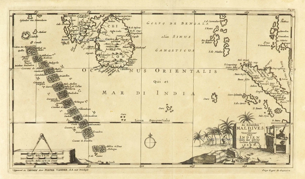
Maldives and Ceylon, by Pieter Van der Aa. 1707
De Eilanden Maldives of Voormuur van Indien met der selver...
[Item number: 32342]
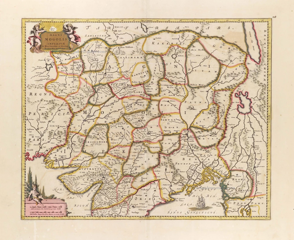
Mongol Empire, by Frederick de Wit. c. 1691-97
Magni Mogolis Imperium.
[Item number: 29092]

Mongol Empire, by Frederick de Wit - Covens & Mortier. After 1721
Magni Mogolis Imperium.
[Item number: 25838]
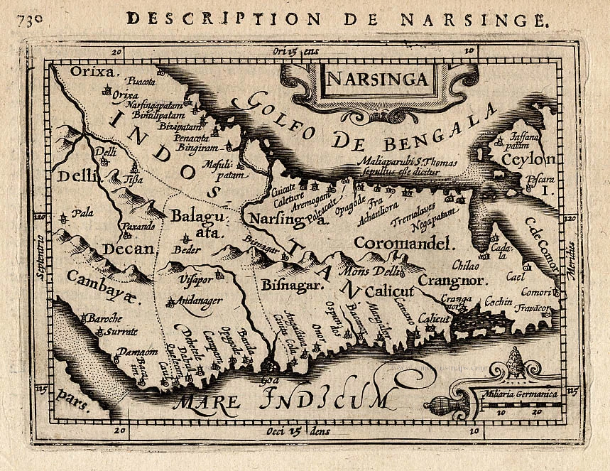
Narsinga, by P. Bertius. 1618
Narsinga.
[Item number: 18299]

Northern India by Vincenzo Coronelli. 1696
Impero del Gran Mogol.
[Item number: 29151]

Scarce
Persian Gulf with Arabia, by Pieter Van der Aa. 1707
De Kusten van Arabie, het Roode Meer, en Persize Zee van Bassora...
[Item number: 32349]

South India and Ceylon by Barent Langenes & Cornelis Claesz c. 1600
Narsinga et Ceylon.
[Item number: 26999]

Southern India, by François Valentyn (Valentijn). 1724-26
Nieuwe kaart van Choromandel ende Malabar.
[Item number: 26896]

Southern India, by Z. Châtelain. 1719
Carte Nouvelle des Terres de Cucan, de Canara, de Malabar, de...
[Item number: 29378]

SCARCE !
View of Surat (India), by Carel Allard. 1685/90
Suratte.
[Item number: 30590]

Sri Lanka (Ceylon) - Trincomalee Bay by François Valentyn (Valentijn). 1724-26
Baay van Tricoen Male.
[Item number: 28627]