Antique maps catalogue
- All recent additions
-
Antique maps
- Polar maps
- World
-
Europe
- Europe Continent
- Belgium
- Belgium - Cities
- The Low Countries
- The Netherlands
- The Netherlands - Cities
- Luxembourg
- France
- France - Cities
- Germany
- Germany - Cities
- Austria
- Italy
- Italy - Cities
- Spain and Portugal
- Greece & Greek Islands
- Switzerland
- British Isles
- British Isles - Cities
- Northern Europe
- Central Europe
- Eastern Europe
- Southeastern Europe
- America
- Asia
- Africa
- Mediterranean Sea
- Australia
- Oceans
- Celestial Maps
- Curiosities
- Title Pages
- Books
- Medieval manuscripts
- Prints
![[No title]](https://sanderusmaps.com/assets/IMG/webp/m27086.webp)
Rare.
Europe, Africa, Arabia & Canada c. 1575
[No title]
[Item number: 27086]

Sea chart of Guinea, by Pieter Goos. 1667
Pas-Caart van Guinea en de Custen daer aen Gelegen van Cabo...
[Item number: 19060]

Indian Ocean, by J.N. Bellin. 1756-1770
Carte Réduite de l'Océan Oriental ou Mers des Indes.
[Item number: 28148]

Scarce
Indian Ocean by Pieter Vander Aa 1714
Basora En de Landschappen Tussen den Eufrat en Tiger stroom, een...
[Item number: 31082]

Indian Ocean (North), by J.B. Elwe. 1792
Partie de la Nouvelle Grande Carte des Indes Orientales,...
[Item number: 2363]

Scarce
Indian Ocean, India, Thailand, and Siam by Pieter Van der Aa. 1707
De Kusten van Guzaratte, Malabar, Bengale en Malacca met die...
[Item number: 32323]
![[No title]](https://sanderusmaps.com/assets/IMG/webp/m28826.webp)
Half globe gore of the Indian Ocean - Madagascar. 1696
[No title]
[Item number: 28826]

Scarce
Indian Ocean & Southeast Asia by Pieter Van der Aa. 1707
Zee-togt van Alfonso d'Albuquerque na de Roode Zee, d'Arabize en...
[Item number: 32321]
Scarce
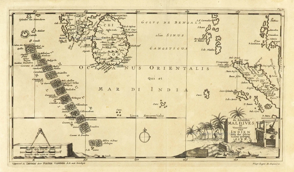
Maldives and Ceylon, by Pieter Van der Aa. 1707
De Eilanden Maldives of Voormuur van Indien met der selver...
[Item number: 32342]
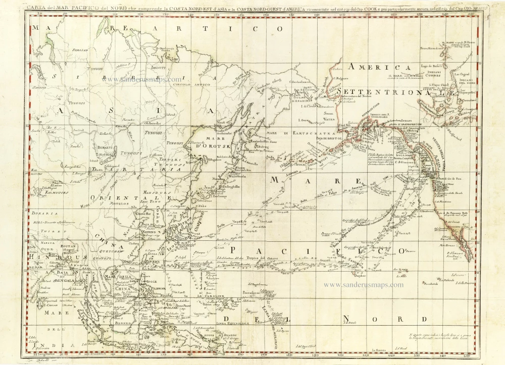
Chart of the Northern Pacific Ocean, Northeastern Asia, and Alaska by John Meares. 1796
Carta del Mar Pacifico del Nord che comprende la Costa...
[Item number: 30731]
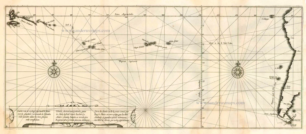
Rare chart showing the route taken by Schouten and le Maire from South America to New Guinea, by Michiel Colijn. 1622
Caerte van de zeylage van Jacob le Maire over de Zuydzee,...
[Item number: 25104]

Pacific Ocean (North) by Francesco & Paolo Santini 1776-79
Carte des Nouvelles Decouvertes au Nord de la Mer du Sud, tant à...
[Item number: 26979]

Sea chart of South African Coast, by Pieter Goos. 1667
Pas-Kaarte van de Zuyd-West-Kust van Afrika; van Cabo Negro tot...
[Item number: 19073]
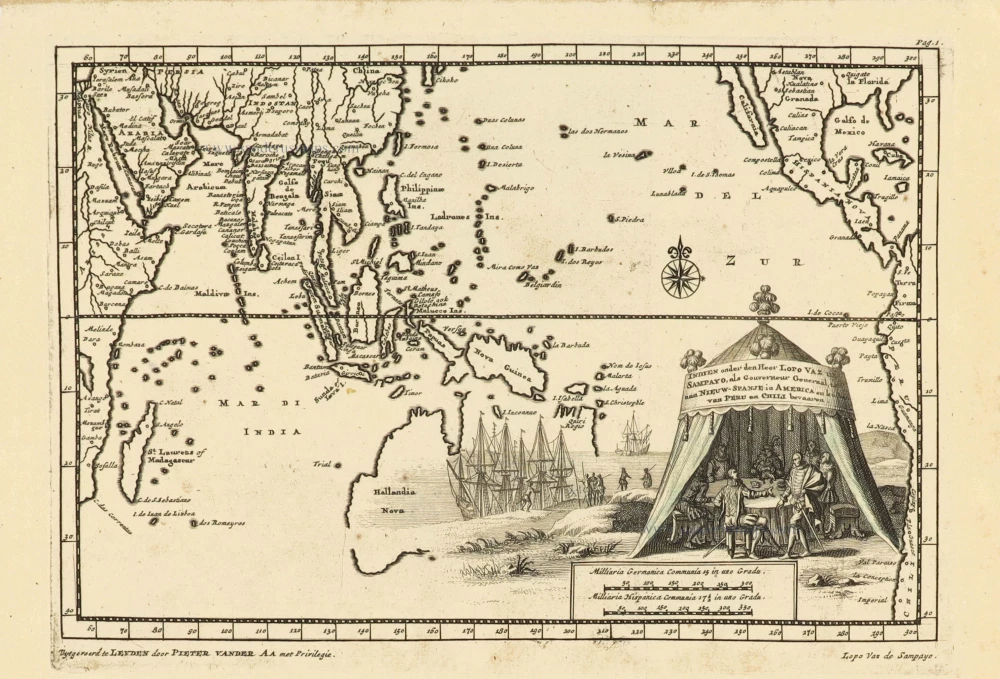
Southeast Asia and Australia, by Pieter Van der Aa. 1707
Indien onder den Heer Lopo Vaz de Sampayo, als Gouverneur...
[Item number: 32359]

Rare and interesting map
Voyage of Magellan from Spain to Asia, by Pieter Van der Aa. 1707
Scheeps-Togt door Ferdinand Magellaan uit Kastilien gedaan na R....
[Item number: 32347]
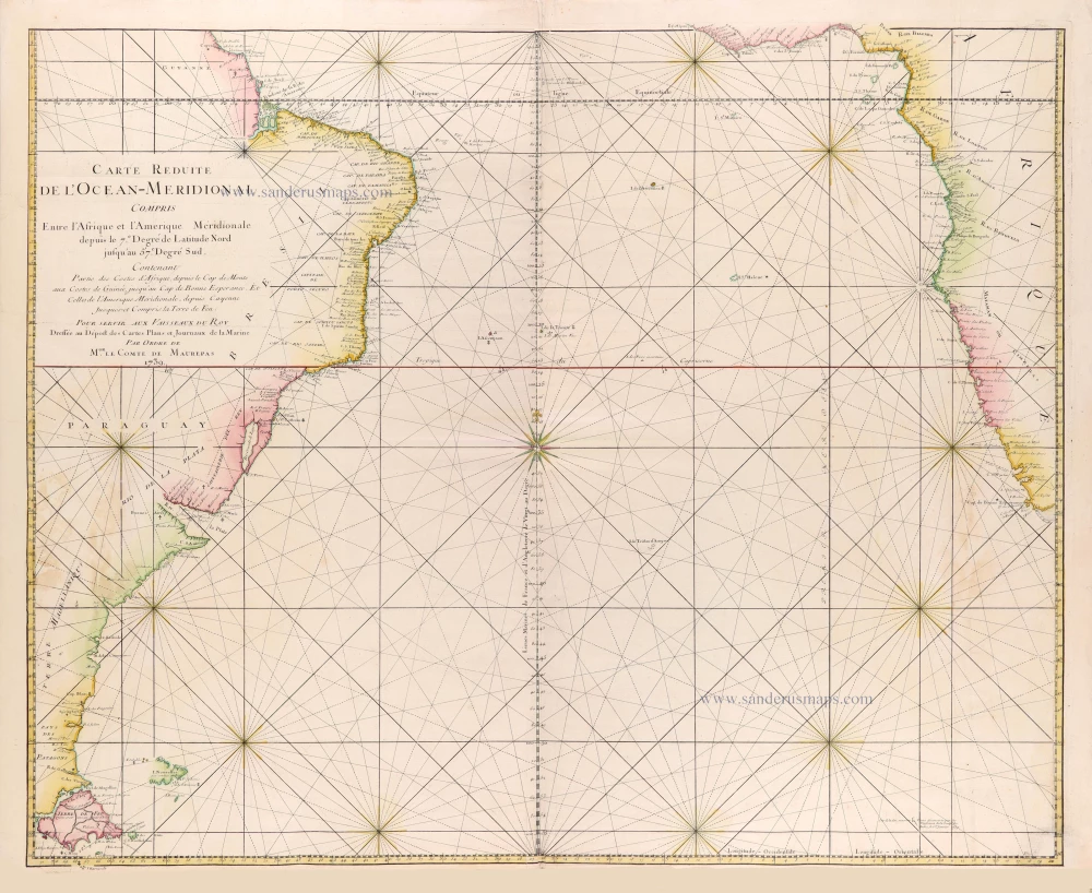
Southern Atlantic Ocean by Jacques Nicolas Bellin. 1765
Carte réduite de l'Océan-méridional, compris entre l'Afrique et...
[Item number: 31446]
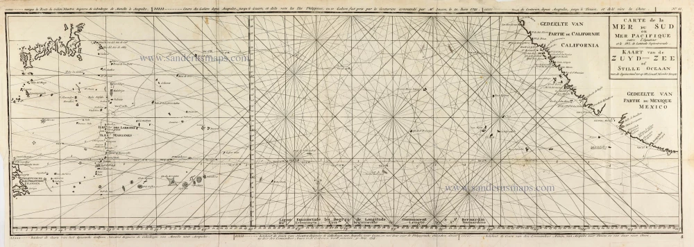
Map of the southern Pacific, showing a part of the path of George Anson's voyage around the world. 1751
Carte de la Mer du Sud ou Mer Pacifique entre l'Equateur et le...
[Item number: 30609]

Map of the southern Pacific, showing a part of the path of George Anson's voyage around the world. 1748
Carte de la Mer du Sud ou Mer Pacifique. Entre l'Equateur et le...
[Item number: 30330]
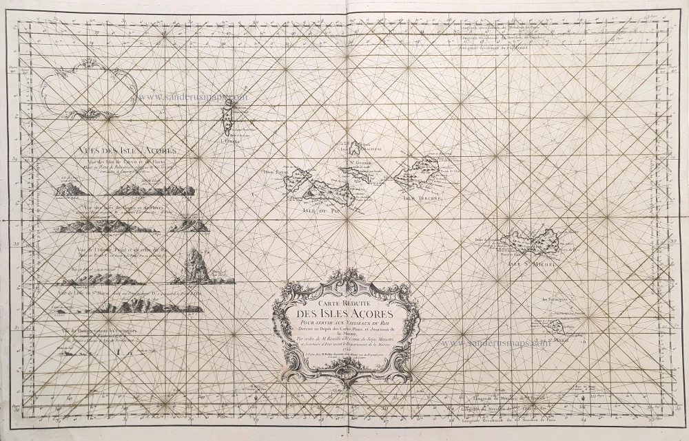
The Azores, by J.N. Bellin. 1756-1770
Carte Réduite des Isles Açores.
[Item number: 28977]
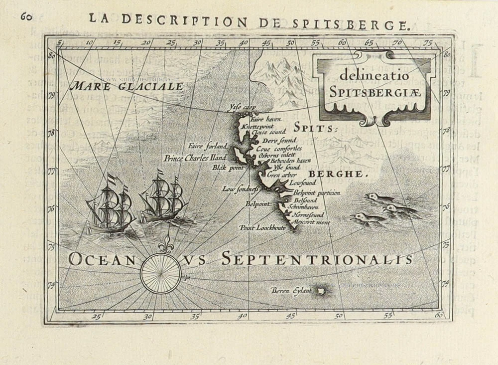
Spitsbergen (Svalbard) by Petrus Bertius 1618
Delineatio Spitsbergiae.
[Item number: 31456]
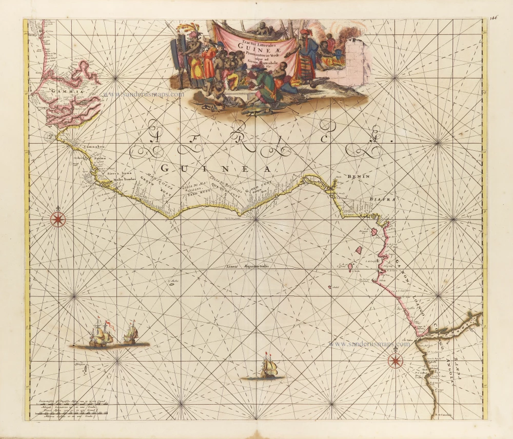
Tropical Atlantic Coast of Africa, by Frederick de Wit. c. 1691-97
Tractus Littorales Guineae a Promontorio Verde usque ad Sinum...
[Item number: 29258]