Antique maps catalogue
- All recent additions
-
Antique maps
- Polar maps
- World
-
Europe
- Europe Continent
- Belgium
- Belgium - Cities
- The Low Countries
- The Netherlands
- The Netherlands - Cities
- Luxembourg
- France
- France - Cities
- Germany
- Germany - Cities
- Austria
- Italy
- Italy - Cities
- Spain and Portugal
- Greece & Greek Islands
- Switzerland
- British Isles
- British Isles - Cities
- Northern Europe
- Central Europe
- Eastern Europe
- Southeastern Europe
- America
- Asia
- Africa
- Mediterranean Sea
- Australia
- Oceans
- Celestial Maps
- Curiosities
- Title Pages
- Books
- Medieval manuscripts
- Prints

Canary Islands, by Joan Blaeu. 1664-65
Insulae Canariae alias Fortunatae Dictae
[Item number: 14157]

Cape Verde Islands, by Covens & Mortier. 1721-41
Isles du Cap Verd Hispanis Islas de Cabo Verde Belgis de Soute...
[Item number: 23621]

One of the most elaborately engraved maps ever published.
Pacific by Zacharias Châtelain after Nicolas de Fer. 1719
Carte tres Curieuse de la Mer du Sud, Contenant des Remarques...
[Item number: 29466]
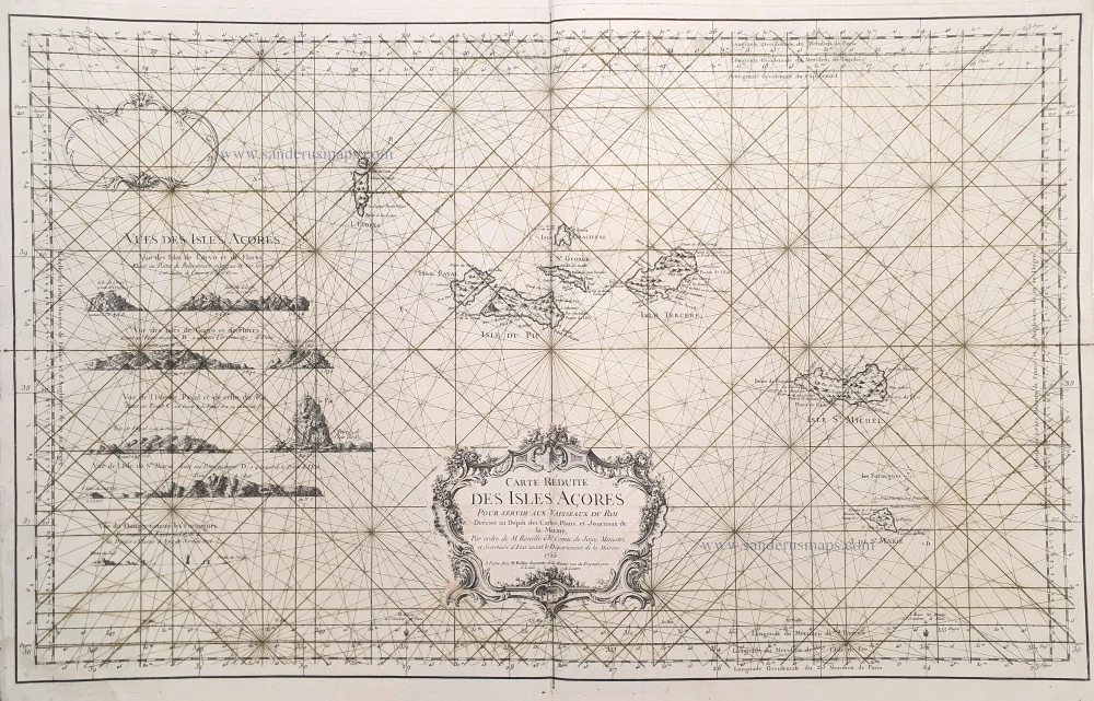
The Azores, by J.N. Bellin. 1756-1770
Carte Réduite des Isles Açores.
[Item number: 28977]
![[No title]](https://sanderusmaps.com/assets/IMG/webp/m27086.webp)
Rare.
Atlantic Ocean - Europe, Africa & Eastern Canada by Giovanni Francesco Camocio c. 1575
[No title]
[Item number: 27086]

The first sea chart - wall map - relating to North America to use the Mercator projection
Atlantic Ocean. by P. Goos - J. Van Keulen c. 1680
West-Indische Paskaert waer in de graden der breedde over...
[Item number: 25938]

Azores, by Abraham Ortelius. 1612
Açores Insulae.
[Item number: 29890]

Bermuda by Joannes Janssonius. 1666
Mappa Aestivarum Insularum alias Barmudas dictarum, ...
[Item number: 29951]

Canary Islands - Madeira , by J.N. Bellin. 1756-1770
Carte Reduite des Costes Occidentales d'Afrique ... et les Isles...
[Item number: 28116]

Canary Islands by Covens & Mortier 1721-41
Insulae Canariae olim Fortunatae Dictae.
[Item number: 25829]
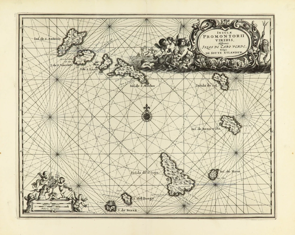
Cape Verde Islands by Dapper O. 1668
Insulae Promotorii viridis Hispanis - Illas de Cabo Verde,...
[Item number: 30938]

Cape Verde Islands, by Coronelli V.M. 1691
Bocche del Fiume Negro et Isole di Capo Verde
[Item number: 23167]
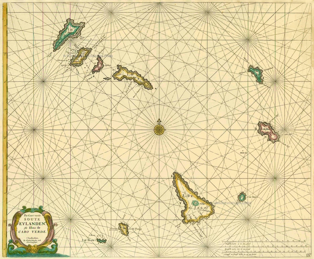
Cape Verde Islands, by Doncker H. 1686
Pas-Caart vande Soute Eylanden ofte Ilhas de Cabo Verde
[Item number: 13643]
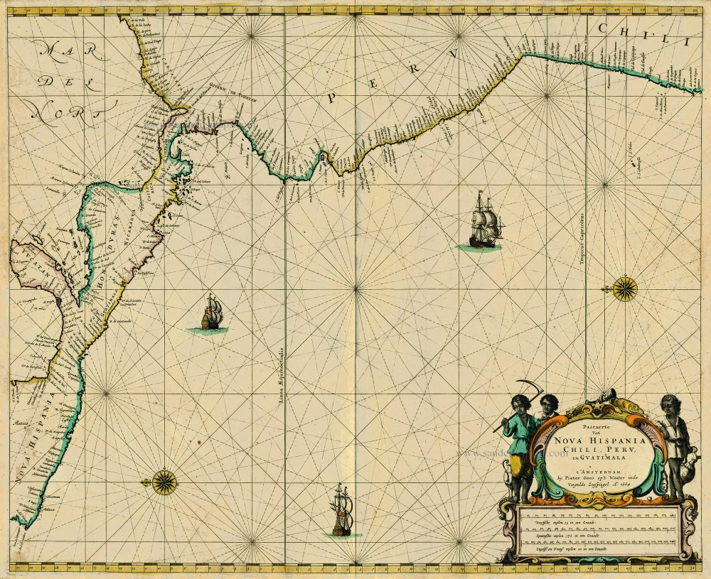
Central America, by Pieter Goos. 1667
Pascaerte van Nova Hispania Chili, Peru, en Guatimala
[Item number: 19031]
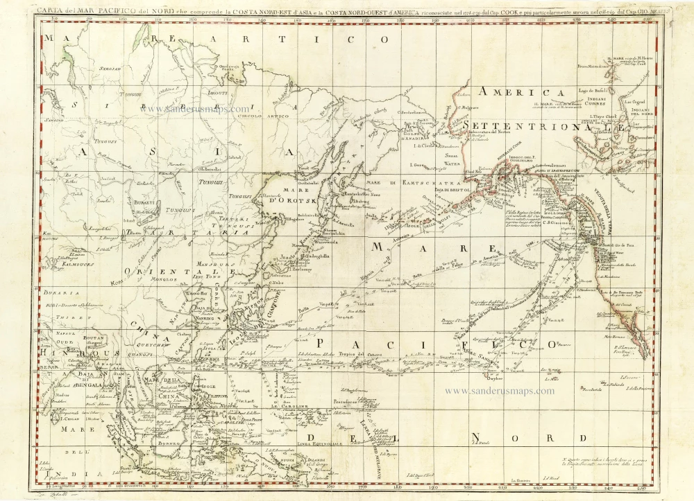
Chart of the Northern Pacific Ocean, Northeastern Asia, and Alaska by John Meares. 1796
Carta del Mar Pacifico del Nord che comprende la Costa...
[Item number: 30731]
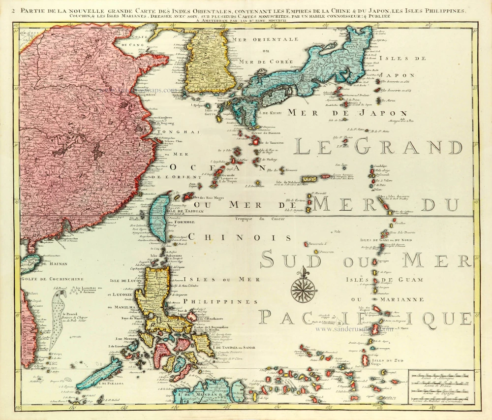
East Asia (Japan - Philippines) by J.B. Elwe. 1792
Partie de la Nouvelle Grande Carte des Indes Orientales...
[Item number: 31803]
![[No title]](https://sanderusmaps.com/assets/IMG/webp/m28826.webp)
Half globe gore of the Indian Ocean - Madagascar. 1696
[No title]
[Item number: 28826]

Scarce
Indian Ocean & Southeast Asia by Pieter Van der Aa. 1707
Zee-togt van Alfonso d'Albuquerque na de Roode Zee, d'Arabize en...
[Item number: 32321]

First folio sea chart from the Dutch Golden Age
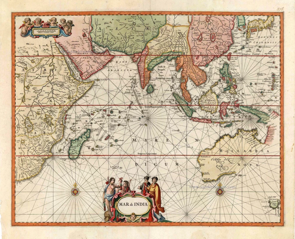
Indian Ocean by J. Janssonius 1650
Mar di India.
[Item number: 32184]

Scarce
Indian Ocean by Pieter Vander Aa 1714
Basora En de Landschappen Tussen den Eufrat en Tiger stroom, een...
[Item number: 31082]

Indian Ocean, by J.N. Bellin. 1756-1770
Carte Réduite de l'Océan Oriental ou Mers des Indes.
[Item number: 28148]
Very rare second state, including the Tasman discoveries (Australia).
Indian Ocean, by Petrus Schenk c. 1700
Mar di India.
[Item number: 27775]

Scarce
Indian Ocean, India, Thailand, and Siam by Pieter Van der Aa. 1707
De Kusten van Guzaratte, Malabar, Bengale en Malacca met die...
[Item number: 32323]
Scarce
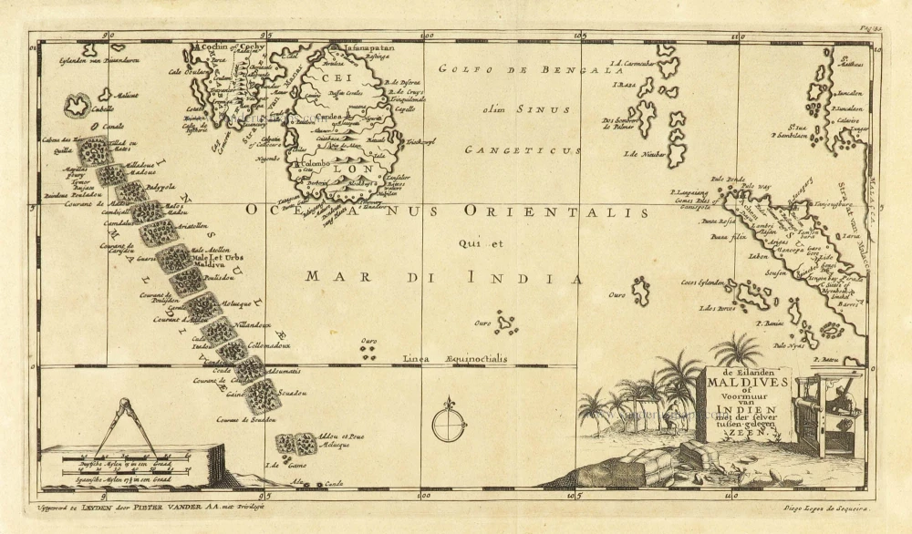
Maldives and Ceylon, by Pieter Van der Aa. 1707
De Eilanden Maldives of Voormuur van Indien met der selver...
[Item number: 32342]
Map of the southern Pacific, showing a part of the path of George Anson's voyage around the world. 1751
Carte de la Mer du Sud ou Mer Pacifique entre l'Equateur et le...
[Item number: 30609]

Map of the southern Pacific, showing a part of the path of George Anson's voyage around the world. 1748
Carte de la Mer du Sud ou Mer Pacifique. Entre l'Equateur et le...
[Item number: 30330]
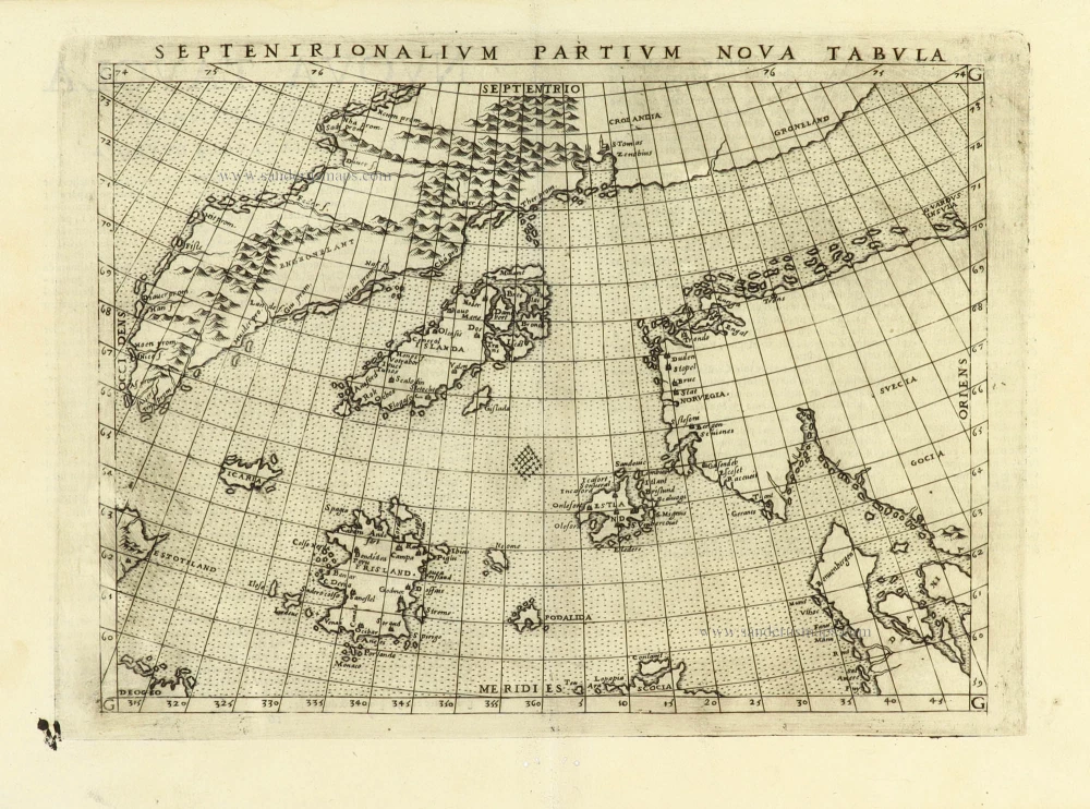
Early map of the North Atlantic
Northern Atlantic Ocean by Girolamo Ruscelli. 1574
Septenirionalium Partium Nova Tabula.
[Item number: 32185]

New Guinea, by W.C. Schouten 1618
Caarte van Nova Guinea, Nieulijck inden iare 1616 bezeijlt, ende...
[Item number: 25400]
Heightened in gold!
The Canary Islands, by Pieter Goos. 1666
Caarte voor en Gedeelte der Canarise Eylanden als Canaria,...
[Item number: 25612]

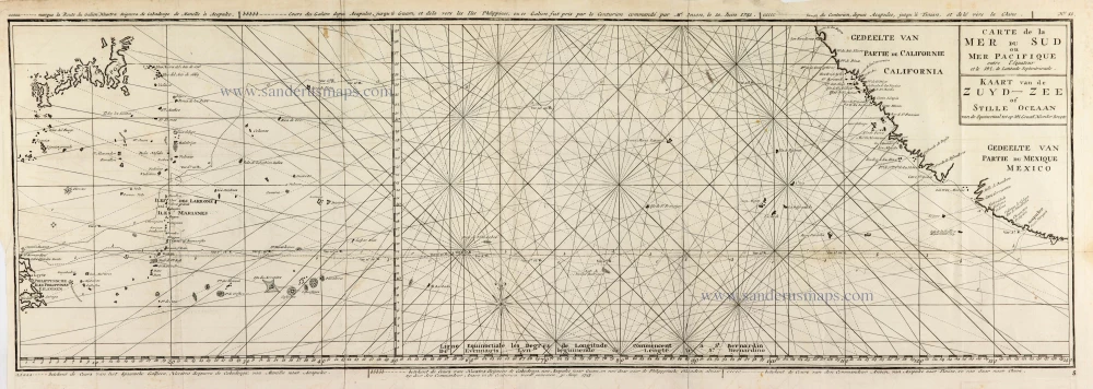
The Northern Pacific Ocean, by T.C. Lotter. 1780
Carte de l'Ocean Pacifique au Nord de l'Equateur, et des Cotes...
[Item number: 11984]
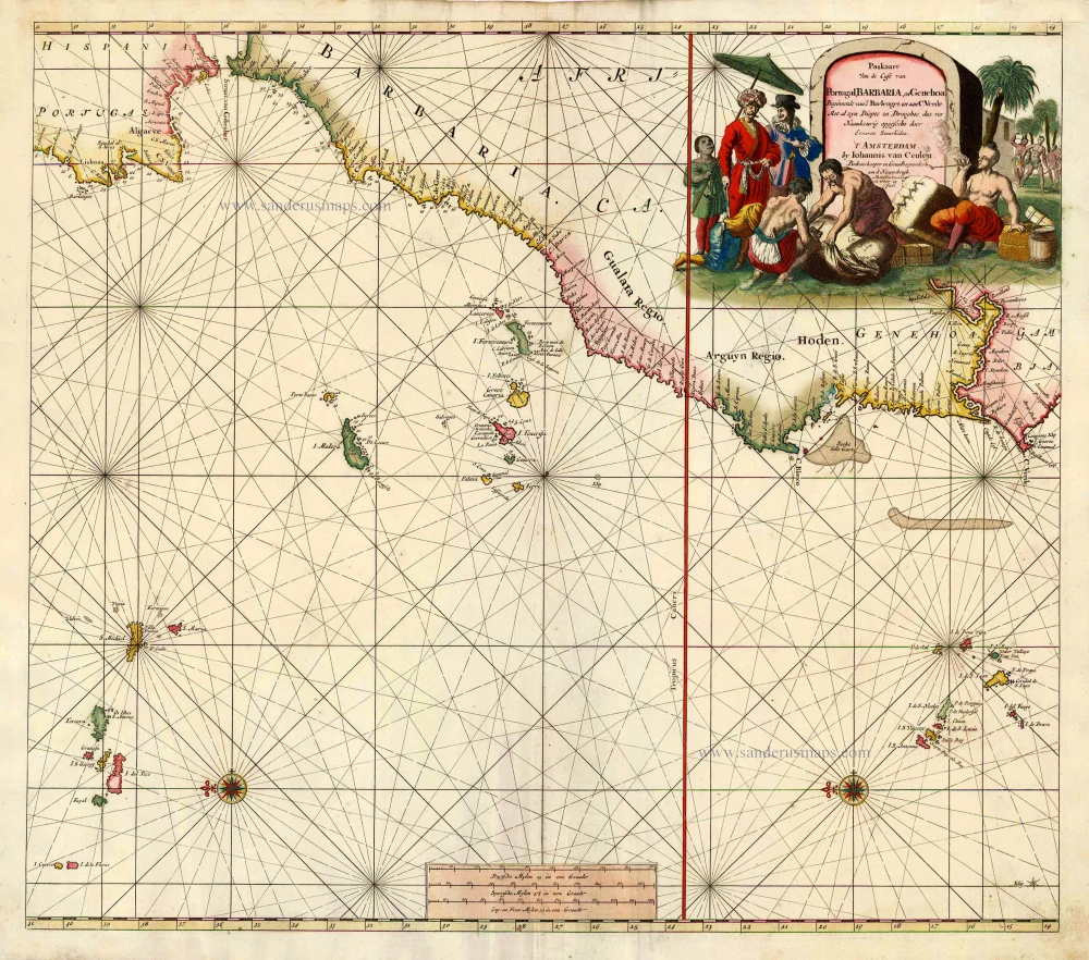
Sea chart of the northwest coast of Africa, with the Azores, Canary Islands and Cape Verde Islands, by Johannes Van Keulen. 1680-1694
Paskaart van de Cust van Portugal, Barbaria, en Genehoa...
[Item number: 26808]
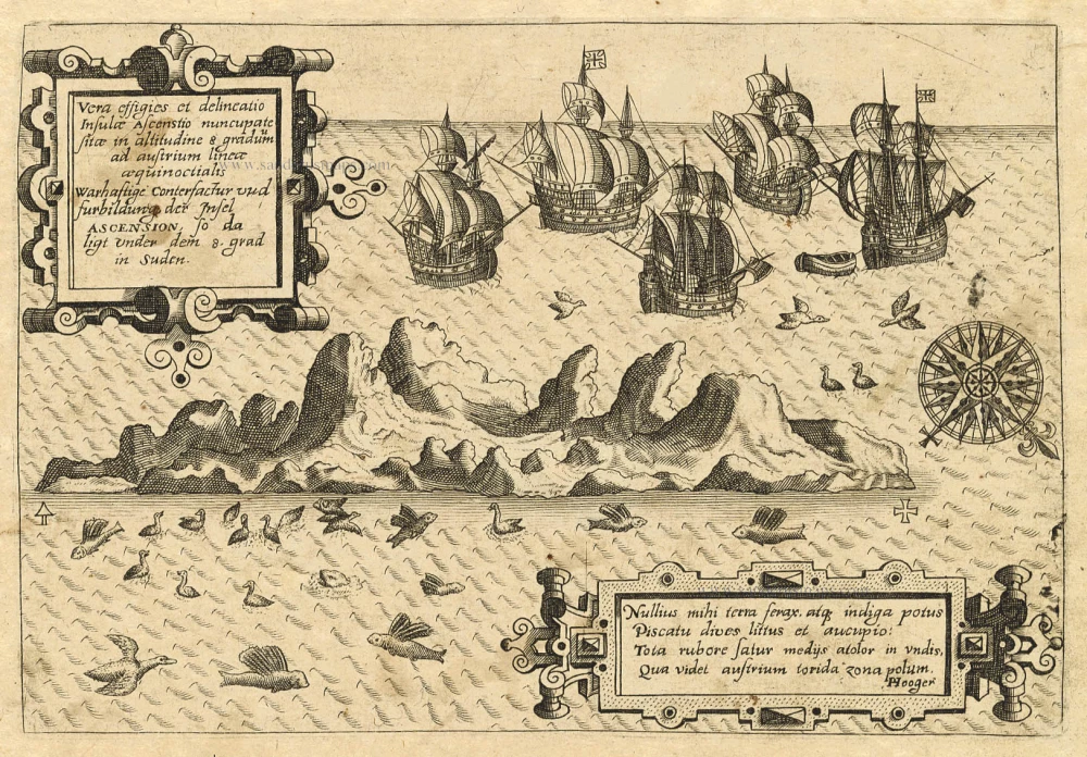
Old antique map of Ascension by Th. de Bry 1598-1613
Vera Effigies et Delineatio Insulae, Ascenstio Nuncupatae Sitae...
[Item number: 20732]
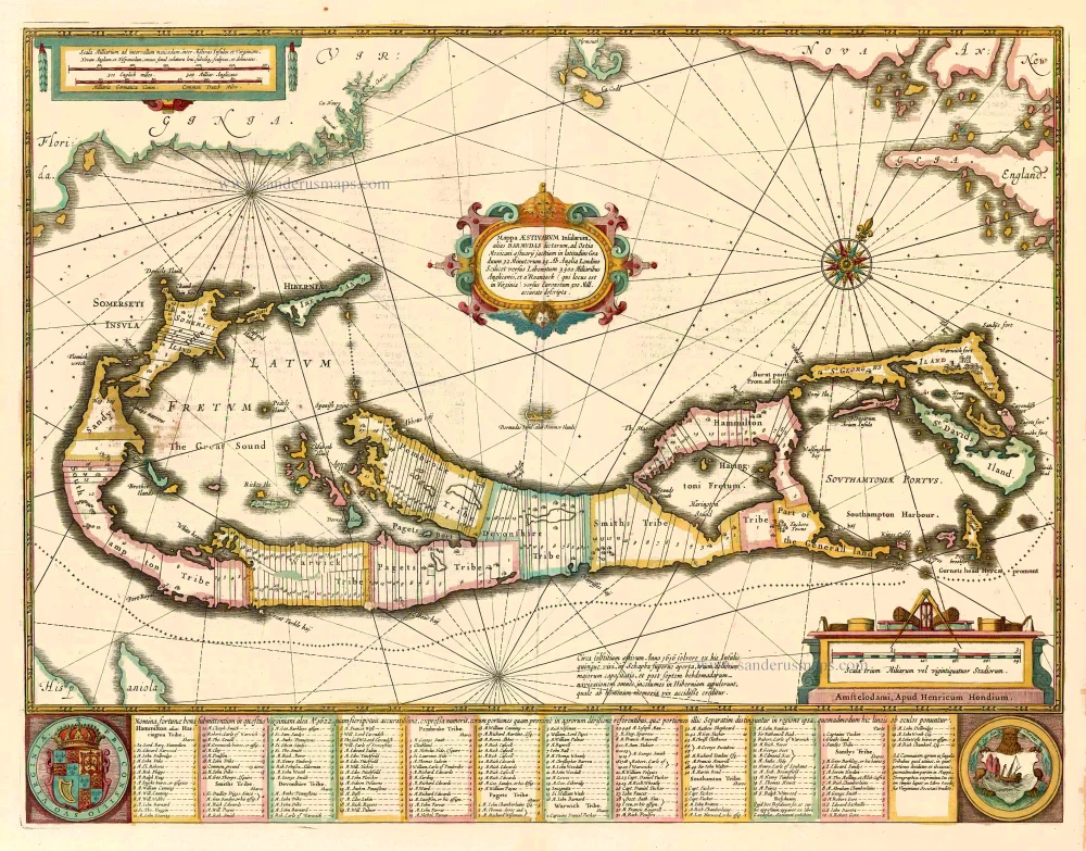
Bermuda, by Johannes Janssonius. 1641
Mappa Aestivarum Insularum alias Barmudas dictarum, ...
[Item number: 26460]

Canary Islands by Pieter van der Aa. 1713
Canaries, ou Iles Fortunées.
[Item number: 26163]

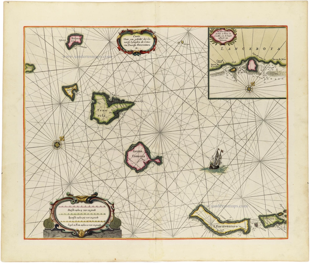
Canary Islands, by Hendrick Doncker. 1686
Canarische Eylanden Canaria Tenerifa, Forteventura etc. t'...
[Item number: 15419]

Indian Ocean (North), by J.B. Elwe. 1792
Partie de la Nouvelle Grande Carte des Indes Orientales,...
[Item number: 2363]