Antique maps catalogue
- All recent additions
-
Antique maps
- Polar maps
- World
-
Europe
- Europe Continent
- Belgium
- Belgium - Cities
- The Low Countries
- The Netherlands
- The Netherlands - Cities
- Luxembourg
- France
- France - Cities
- Germany
- Germany - Cities
- Austria
- Italy
- Italy - Cities
- Spain and Portugal
- Greece & Greek Islands
- Switzerland
- British Isles
- British Isles - Cities
- Northern Europe
- Central Europe
- Eastern Europe
- Southeastern Europe
- America
- Asia
- Africa
- Mediterranean Sea
- Australia
- Oceans
- Celestial Maps
- Curiosities
- Title Pages
- Books
- Medieval manuscripts
- Prints
![[No title]](https://sanderusmaps.com/assets/IMG/webp/m28159.webp)
The most mystical world map of all time.
Daniel's Dream Map. The Wittenberg world map. 1560-1600
[No title]
[Item number: 28159]
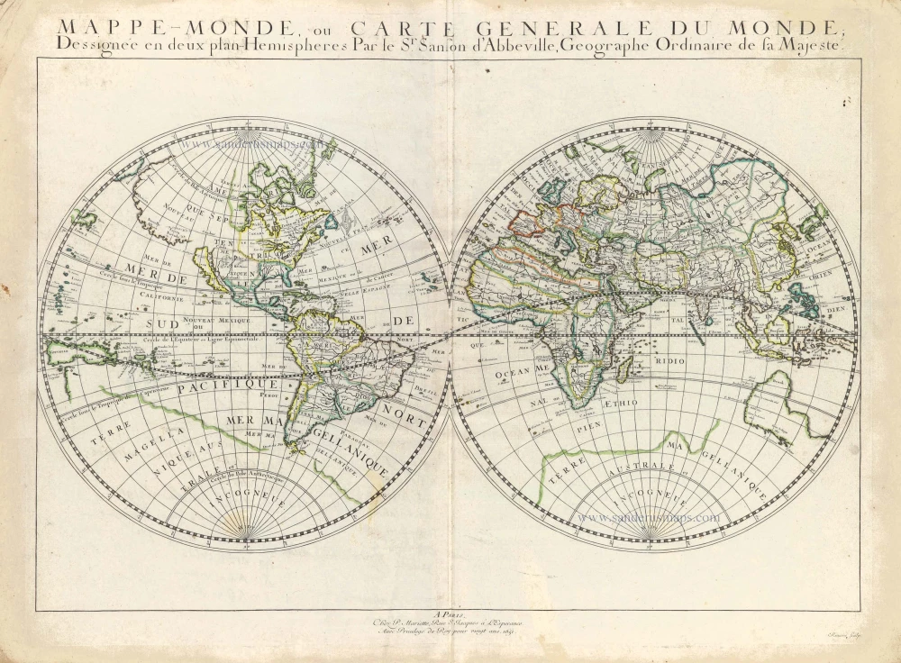
Double hemisphere world map by Nicolas Sanson. 1652
Mappe-Monde, ou Carte Generale du Monde,
[Item number: 29612]

Old, antique map of Ancient World by Ortelius A. 1595
Aevi Veteris, Typus Geographicus
[Item number: 6684]
![Typus Orbis Terrarum, [in set with:] Europa, [and] Asia, [and] Americae Descrip., [and] Africae Descriptio.](https://sanderusmaps.com/assets/IMG/webp/m27088.webp)
World + Continents, by Jodocus Hondius. 1607
Typus Orbis Terrarum, [in set with:] Europa, [and] Asia, [and]...
[Item number: 27088]

Rare title page of Purchas's Pilgrimes, with his portrait and worldmap
Samuel Purchas ' title page with a world map and portrait 1625
Hakluytus Posthumus, or Purchas His Pilgrimes
[Item number: 32417]

The Universal Zeig und Schlaf-Uhr, designed by Zacharias Landteck, published by J.B. Homann. c. 1720
Iohann Baptistae Homanns Neu inventirte Geographische Universal...
[Item number: 32037]

Ancient World by Abraham Ortelius. 1601
Aevi Veteris, Typus Geographicus.
[Item number: 22609]

TERRESTRIAL GLOBE by Valk G. 1707
Cosmotheore, Caelesti nostro Globo, Par; et plane Novus, Hic...
[Item number: 21384]

World map by Louis Brion de la Tour, published by L.C Desnos. 1766-1780
Mappe-Monde
[Item number: 30100]

World by Homann J.B., double hemisphere. c. 1720
Planiglobii Terrestris cum Utroq Hemisphaerio Caelesti Generalis...
[Item number: 32099]

World map by Nicolas Sanson, so-called published by Hubert Jaillot. (Pirated edition by Pierre Mortier). 1692
Mappe-Monde Geo-Hydrographique, ou Description Generale du Globe...
[Item number: 31136]

World map by Zacharias Châtelain. 1713
Mapmonde ou description generale du Globe Terrestre.
[Item number: 29555]

World by Petrus Bertius. 1618
Typus Orbis Terrarum.
[Item number: 33183]
new

World map by Jacques-Nicolas Bellin, published by A.F. Prévost. 1750
An Essay of a New and Compact Map, containing the known parts of...
[Item number: 31883]

World in two hemisphers by Giovanni De Rossi, after Nicolas Sanson. 1677
Mappa Mondo O Vero Carta Generale Del Globo Terestre
[Item number: 32885]
![[No title]](https://sanderusmaps.com/assets/IMG/webp/m28158.webp)
California as an island.
Northern Hemisphere by Johann Baptist Homann. 1731
[No title]
[Item number: 28158]

World map, double hemisphere by Pierre Grégoire Chanlaire. c. 1797
Mappemonde en deux Hémisphères.
[Item number: 28209]

World map, double hemisphere by Pierre Grégoire Chanlaire. c. 1797
Mappe-Monde Physique.
[Item number: 28210]