Antique maps catalogue
- All recent additions
-
Antique maps
- Polar maps
- World
-
Europe
- Europe Continent
- Belgium
- Belgium - Cities
- The Low Countries
- The Netherlands
- The Netherlands - Cities
- Luxembourg
- France
- France - Cities
- Germany
- Germany - Cities
- Austria
- Italy
- Italy - Cities
- Spain and Portugal
- Greece & Greek Islands
- Switzerland
- British Isles
- British Isles - Cities
- Northern Europe
- Central Europe
- Eastern Europe
- Southeastern Europe
- America
- Asia
- Africa
- Mediterranean Sea
- Australia
- Oceans
- Celestial Maps
- Curiosities
- Title Pages
- Books
- Medieval manuscripts
- Prints

Ancient World by Abraham Ortelius. 1601
Aevi Veteris, Typus Geographicus.
[Item number: 22609]

Beautiful example of this important world map
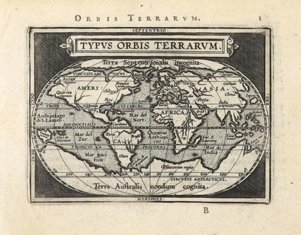
World by Abraham Ortelius. 1584
Typus Orbis Terrarum.
[Item number: 32090]
![Typus Orbis Terrarum [in set with] Africae Tabula Nova [and] Americae sive Novi Orbis, Nova Descriptio [and] Asiae Nova Descriptio [and] Europae.](https://sanderusmaps.com/assets/IMG/webp/m29259.webp)
Superb world set.
Abraham Ortelius, 1584 World and Continents 1584
Typus Orbis Terrarum [in set with] Africae Tabula Nova [and]...
[Item number: 29259]
The world by Abraham Ortelius / Philippe Galle. 1589
Typus Orbis Terrarum.
[Item number: 29605]

Rare original colour.
Two world maps by A. Ortelius, published by J.B. Vrients. 1609
Typus Orbis Terrarum - Globus Terrestris.
[Item number: 29861]
![Typus Orbis Terrarum. [in set with:] America, [and] Europa, [and] Africa, [and] Asia.](https://sanderusmaps.com/assets/IMG/webp/m16457.webp)
Rare first edition
World and Continents by Barent Langenes & Cornelis Claesz. Five maps. 1598
Typus Orbis Terrarum. [in set with:] America, [and] Europa,...
[Item number: 16457]

'One of the supreme examples of map maker's art' (Shirley)
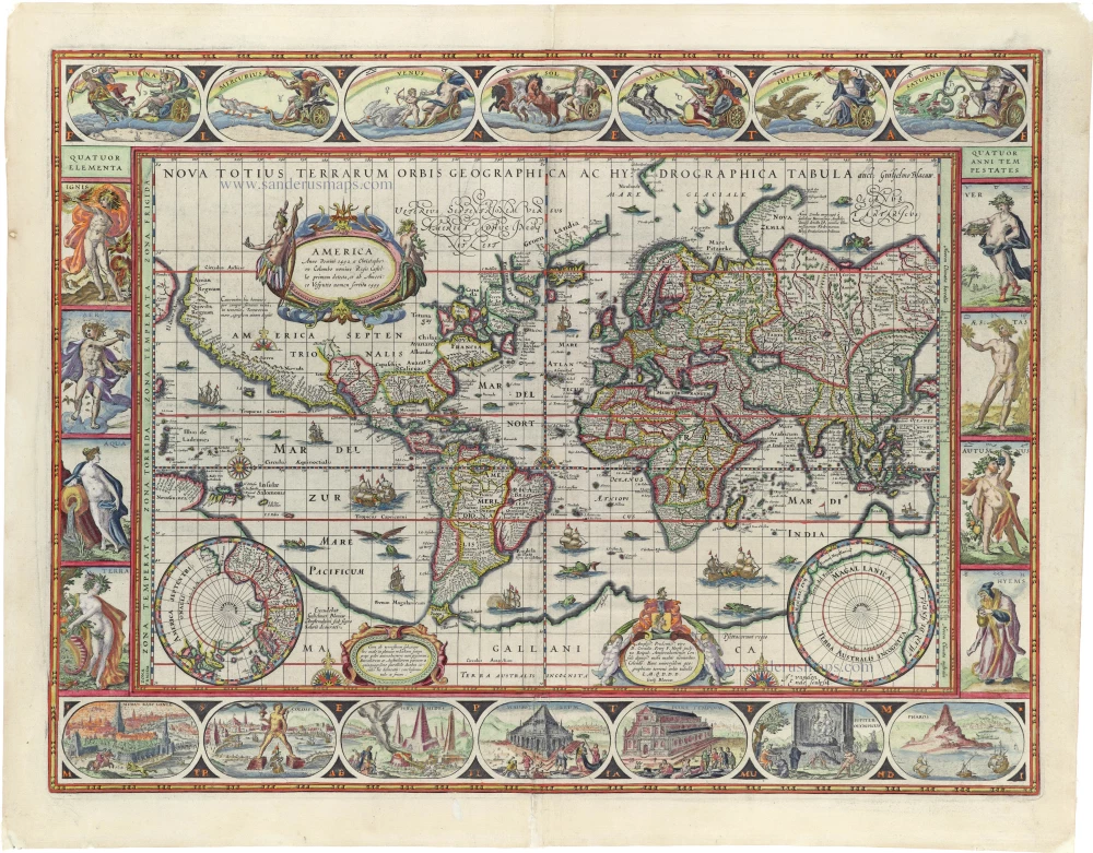
World by Willem Blaeu, in Mercator projection. 1643
Nova Totius Terrarum Orbis Geographica ac Hydrographica.
[Item number: 30271]
The engraving and layout and elegance of decoration are all of the highest standards.
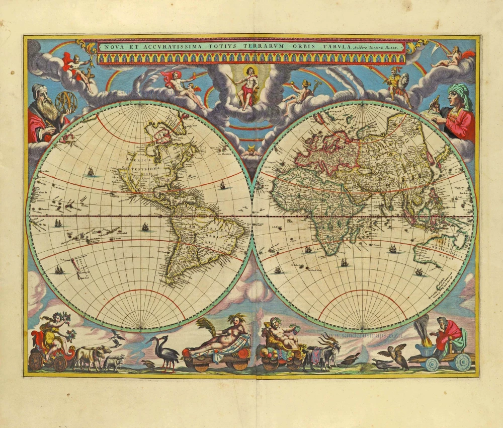
World by Joan Blaeu, double hemisphere. 1659
Nova Et Accuratissima Totius Terrarum Orbis Tabula.
[Item number: 28336]
'One of the supreme examples of map maker's art' (Shirley)
World by Willem Blaeu, in Mercator projection. 1635
Nova Totius Terrarum Orbis Geographica ac Hydrographica.
[Item number: 32683]

World map by Louis Brion de la Tour, published by L.C Desnos. 1766-1780
Mappe-Monde
[Item number: 30100]

World map, double hemisphere by Pierre Grégoire Chanlaire. c. 1797
Mappemonde en deux Hémisphères.
[Item number: 28209]

World map, double hemisphere by Pierre Grégoire Chanlaire. c. 1797
Mappe-Monde Physique.
[Item number: 28210]

Superb old colouring, heightened with gold.
World - Double Hemisphere, by Daniel Stoopendaal 1714
Orbis Terrarum Tabula Recens Emendata Et In Lucem Edita
[Item number: 30635]

Rare first state of Danckerts beautiful world map
Double hemisphere world map by Justus Danckerts c. 1680
Nova Totius Terrarum Orbis Tabula..
[Item number: 32456]

World by Frederik De Wit, double hemisphere. c. 1690
Nova Orbis Tabula in Lucem Edita, A. F. De Wit.
[Item number: 29231]
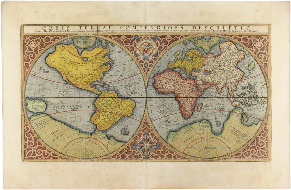
World by Mercator Rumold, double hemisphere. 1613
Orbis Terrae Compendiosa Descriptio.
[Item number: 30942]

TERRESTRIAL GLOBE by Valk G. 1707
Cosmotheore, Caelesti nostro Globo, Par; et plane Novus, Hic...
[Item number: 21384]

World chart by Girolamo Ruscelli. 1574
Carta Marina Nuova Tavola.
[Item number: 32432]

World by Giovanni Magini 1597
Universi Orbis Descriptio.
[Item number: 27837]

Early Mercator projection
World by Giovanni Magini. 1597
Universi Orbis Descriptio Ad Usum Navigantium.
[Item number: 32281]

World in two hemisperes, by Girolamo Ruscelli. 1574
Orbis Descriptio.
[Item number: 32433]
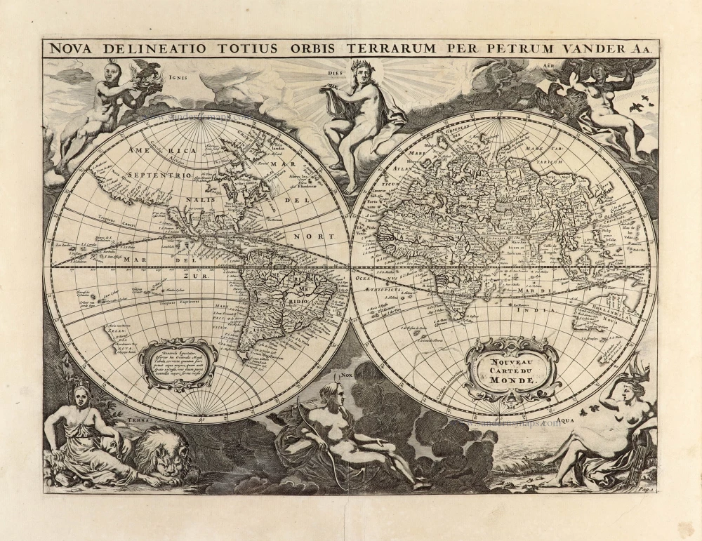
World by Pieter Van der Aa - double hemisphere. 1702
Nova Delineatio Totius Orbis Terrarum per Petrum Van der Aa. -...
[Item number: 30150]
![[No title]](https://sanderusmaps.com/assets/IMG/webp/m28159.webp)
The most mystical world map of all time.
Daniel's Dream Map. The Wittenberg world map. 1560-1600
[No title]
[Item number: 28159]
![[No title]](https://sanderusmaps.com/assets/IMG/webp/m32507.webp)
The most mystical world map of all time.
Daniel's Dream Map. The Wittenberg world map by Hanss Luft. 1560-1600
[No title]
[Item number: 32507]

Rare variant.
World map by H. Bünting - D.A. Veleslavina. 1592
Cosmographia Universalis.
[Item number: 26356]
![Typus Orbis Terrarum, [in set with:] Europa, [and] Asia, [and] Americae Descrip., [and] Africae Descriptio.](https://sanderusmaps.com/assets/IMG/webp/m27088.webp)
World + Continents, by Jodocus Hondius. 1607
Typus Orbis Terrarum, [in set with:] Europa, [and] Asia, [and]...
[Item number: 27088]

A fine ornate example of the decorative cartography of the time.
Double-hemisphere world map by Henricus Hondius. 1641
Nova Totius Terrarum Orbis Geographica ac Hydrographica Tabula....
[Item number: 28768]

World map by Nicolas Sanson, so-called published by Hubert Jaillot. (Pirated edition by Pierre Mortier). 1692
Mappe-Monde Geo-Hydrographique, ou Description Generale du Globe...
[Item number: 31136]
![[No title]](https://sanderusmaps.com/assets/IMG/webp/m28158.webp)
California as an island.
Northern Hemisphere by Johann Baptist Homann. 1731
[No title]
[Item number: 28158]

The Universal Zeig und Schlaf-Uhr, designed by Zacharias Landteck, published by J.B. Homann. c. 1720
Iohann Baptistae Homanns Neu inventirte Geographische Universal...
[Item number: 32037]

World by Homann J.B., double hemisphere. c. 1720
Planiglobii Terrestris cum Utroq Hemisphaerio Caelesti Generalis...
[Item number: 32099]
![[No title]](https://sanderusmaps.com/assets/IMG/webp/m30649.webp)
Rare 1525 edition in nice old colour.
Ptolemaic world by Lorenz Fries after Martin Waldseemüller. 1525
[No title]
[Item number: 30649]
Rare 1525 edition of the second modern world map by Fries, in nice old colour.
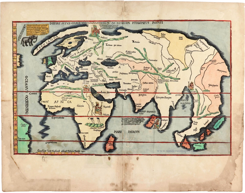
Modern world map, by Lorenz Fries, after Martin Waldseemüller. 1525
Diefert Situs Orbis Hydrographorum Ab Eo Quem Ptolomeus Posuit.
[Item number: 30661]

World by Petrus Bertius, published by Jodocus Hondius II. 1618
Typus Orbis Terrarum.
[Item number: 31520]
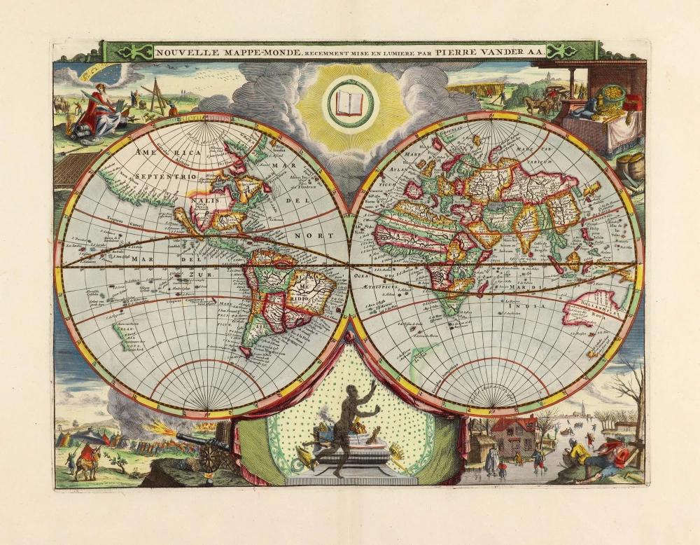
World by Pieter Van der Aa, double hemisphere. 1710
Nouvelle Mappe-Monde,
[Item number: 29136]

World by Porcacchi Tommaso. 1572
Descrittione Del Mappamondo.
[Item number: 28910]