Our catalogue catalogue
- All recent additions
-
Antique maps
- Polar maps
- World
-
Europe
- Europe Continent
- Belgium
- Belgium - Cities
- The Low Countries
- The Netherlands
- The Netherlands - Cities
- Luxembourg
- France
- France - Cities
- Germany
- Germany - Cities
- Austria
- Italy
- Italy - Cities
- Spain and Portugal
- Greece & Greek Islands
- Switzerland
- British Isles
- British Isles - Cities
- Northern Europe
- Central Europe
- Eastern Europe
- Southeastern Europe
- America
- Asia
- Africa
- Mediterranean Sea
- Australia
- Oceans
- Celestial Maps
- Curiosities
- Title Pages
- Books
- Medieval manuscripts
- Prints

Splendid red morocco binding
Ortelius Atlas. 1598
Theatre de l'Univers, contenant les cartes de tout le Monde....
[Item number: 32578]
new
The engraving and layout and elegance of decoration are all of the highest standards.
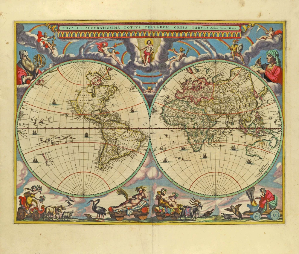
World by Joan Blaeu, double hemisphere. 1659
Nova Et Accuratissima Totius Terrarum Orbis Tabula.
[Item number: 28336]
new
![[No title]](https://sanderusmaps.com/assets/WEBP/m32499.webp)
Rare
Coronelli's globe gores covering Southeast Asia 1688
[No title]
[Item number: 32499]
new

Rare Visscher map of Het Zwin, in a stunning colouring and gold-heightened, all in the style of Dirk Van Santen
Oost-Vrije (West Zeeuws-Vlaanderen), by Nicolaes Visscher. 1666
't Meerderdeel van 't OOST-VRYE in Vlaenderen Vertonende...
[Item number: 32588]
new

Important and rare plan from the sixth volume of Braun & Hogenberg's famous town books
Warsaw by Georg Braun & Frans Hogenberg. (Warszawa) 1635
Varsovia.
[Item number: 32623]
new

America by Jodocus Hondius. 1630
America
[Item number: 32577]
new
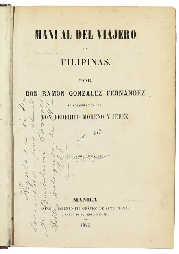
Rare
Philippines, travel book by Ramon Gonzalez Fernandez & Federico Moreno y Jeréz 1875
Manual del viajero en Filipinas.
[Item number: 32605]
new

The most desirable of Dutch atlas title pages
Frontispiece of Joannes Jansonius' Atlas Contractus. 1666
Joannis Janssonii Atlas Contractus
[Item number: 32581]
new

'One of the finest maps published anywhere in the seventeenth century'
Great Brittain by Joan Blaeu 1645
Britannia prout divisa fuit temporibus Anglo-Saxonum, praesertim...
[Item number: 32188]
new

Important map
North Atlantic Ocean by Abraham Ortelius 1598
Septentrionalium Regionum Descrip.
[Item number: 32606]
new

From the famous work of the insects of Surinam
Pineapple with Cockroaches by Maria Sibylla Merian. 1771
Ananas.
[Item number: 32508]
new

Spectacular view by Hoefnagel
Antwerp, by Georg Braun and Frans Hogenberg, after G. Hoefnagel. 1596
Antverpia.
[Item number: 32468]
new
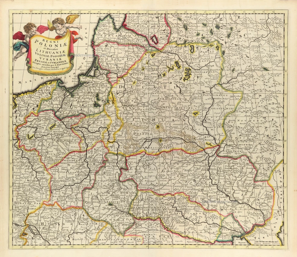
Scarce
Poland, Lithuania, and Ukraine by Justus Danckerts c. 1680
Regni Poloniae et Ducatus Lithuaniae Voliniae, Podoliae Ucraniae...
[Item number: 32513]
new

Rare
Title page of Hendrick Doncker's Zee-Atlas - Water World. 1661
L'Atlas de Mer, ou Monde d'Eaue. Remonstrant toutes les costes...
[Item number: 32622]
new

Joannes van Keulen, Allegoric title page - frontispiece to part IV of the Zee-Fakkel 1715
No title
[Item number: 32607]
new

Rare first state
Bohemia (Czech Republic) by J. Janssonius. c. 1620-1650
Bohemia in Suas Partes Geographicé Distincta.
[Item number: 32469]
new

From the first Dutch folio printed sea atlas
The Antilles by Joannes Janssonius. 1650
Insularum Hispaniolae et Cubae, Cum Insulis circumjacentibus.
[Item number: 32621]
new

Rare
Toscana (Tuscany) by Joannes Janssonius. 1675
Toscana Inferiore, Detta Anticamente Tuscia Suburbicaria.
[Item number: 32601]
new

Exceptional beautiful colour
Gent by Georg Braun & Frans Hogenberg. 1693
Gandavum, Amplissima Flandriae urbs, ...
[Item number: 32474]
new

Superb colouring
Title Page by Ortelius Abraham. 1579
Theatrum Orbis Terrarum.
[Item number: 32516]
new

Superb colouring
Paris, by Matthaeus Seutter 1631-1641
Le Plan de Paris, ses Faubourgs et ses Environs, divisé suivant...
[Item number: 32538]
new

Scarce and important map
Albania by Johannes Laurenberg, published by Joannes Janssonius. 1650
Epirus hodie vulgo Albania.
[Item number: 32620]
new
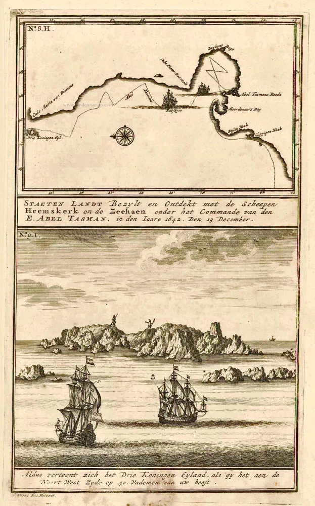
New Zealand, by François Valentyn. 1726
Staeten Landt Bezylt en Ontdekt met de Scheepen Heemskerk en de...
[Item number: 27922]
new
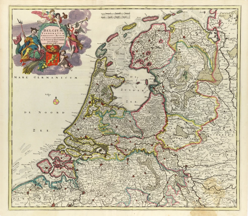
Rare map of the Seven Provinces by Justus Danckerts
VII Provinces (Seven Provinces) by Justus Danckerts. 1696-1713
Belgium Foederatum Emendatius Auctum et Novissime Editum
[Item number: 32500]
new

RARE
Chart by Anthonie Jacobsz, the Flemish coast. 1644
De Cust van Vlaenderen Beginnende vande Wielingen tot aen de...
[Item number: 32608]
new

Chart of the Southern North Sea, by Joannes Van Keulen 1680-1694
Pas Caerte van Texel, tot aende Hoofden; Begrypende in sich de...
[Item number: 32628]
new

Riga & Kaliningrad by Braun & Hogenberg. 1599
Die Furstliche Hauptt Statt Konigssbergk in Preussen. Mons...
[Item number: 32582]
new

From the first Dutch folio printed sea atlas
Puerto Rico and the Carribean, by Joannes Janssonius. 1650
Insula S. Iuan de Puerto Rico Caribes, Vel Canibalum Insulae.
[Item number: 32625]
new

Famous frontispiece by Romeyn de Hooghe
Title page of Pierre Mortier's Atlas Maritime 1693
Atlas Maritime
[Item number: 32627]
new

Spectacular title page
Title page of Frederick de Wit's Atlas Maior, published by Christophorum Browne. 1706
Atlas Maior.
[Item number: 32532]
new

Scarce and decorative map
Italy by Theodore Danckerts. c. 1680
Novissima et Accuratissima totius Italiae Corsicae et Sardiniae.
[Item number: 32501]
new
![[No title]](https://sanderusmaps.com/assets/WEBP/m32507.webp)
The most mystical world map of all time.
Daniel's Dream Map. The Wittenberg world map by Hanss Luft. 1560-1600
[No title]
[Item number: 32507]
new

Rare
Plan of Gent (Ghent), published by M. Delhoungne. 1830
Plan de la ville de Gand et de ses Faubourgs.
[Item number: 32618]
new

Scarce
Scandinavia by Justus Danckerts c. 1680
Accuratissima Regnorum et Norvegiae, Tabula.
[Item number: 32613]
new

From the first Dutch folio printed sea atlas
Spanish coast by J. Janssonius. 1650
Pascaart Vande Custen Van Andaluzia, Portugal, Gallissien,...
[Item number: 32626]
new
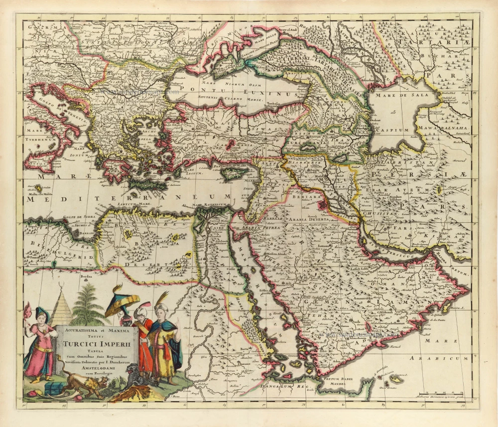
Ottoman Empire by Danckerts J. c. 1680
Accuratissima et Maxima Totius Turcici Imperii Tabula cum...
[Item number: 32518]
new