Antique maps catalogue
- All recent additions
-
Antique maps
- Polar maps
- World
-
Europe
- Europe Continent
- Belgium
- Belgium - Cities
- The Low Countries
- The Netherlands
- The Netherlands - Cities
- Luxembourg
- France
- France - Cities
- Germany
- Germany - Cities
- Austria
- Italy
- Italy - Cities
- Spain and Portugal
- Greece & Greek Islands
- Switzerland
- British Isles
- British Isles - Cities
- Northern Europe
- Central Europe
- Eastern Europe
- Southeastern Europe
- America
- Asia
- Africa
- Mediterranean Sea
- Australia
- Oceans
- Celestial Maps
- Curiosities
- Title Pages
- Books
- Medieval manuscripts
- Prints

Famous and beautiful map
Ypres (Ieper) Castellania, by Sanderus A. 1732
Nova et Exacta Tabula Geographica Salae et Castellaniae Iprensis...
[Item number: 27434]

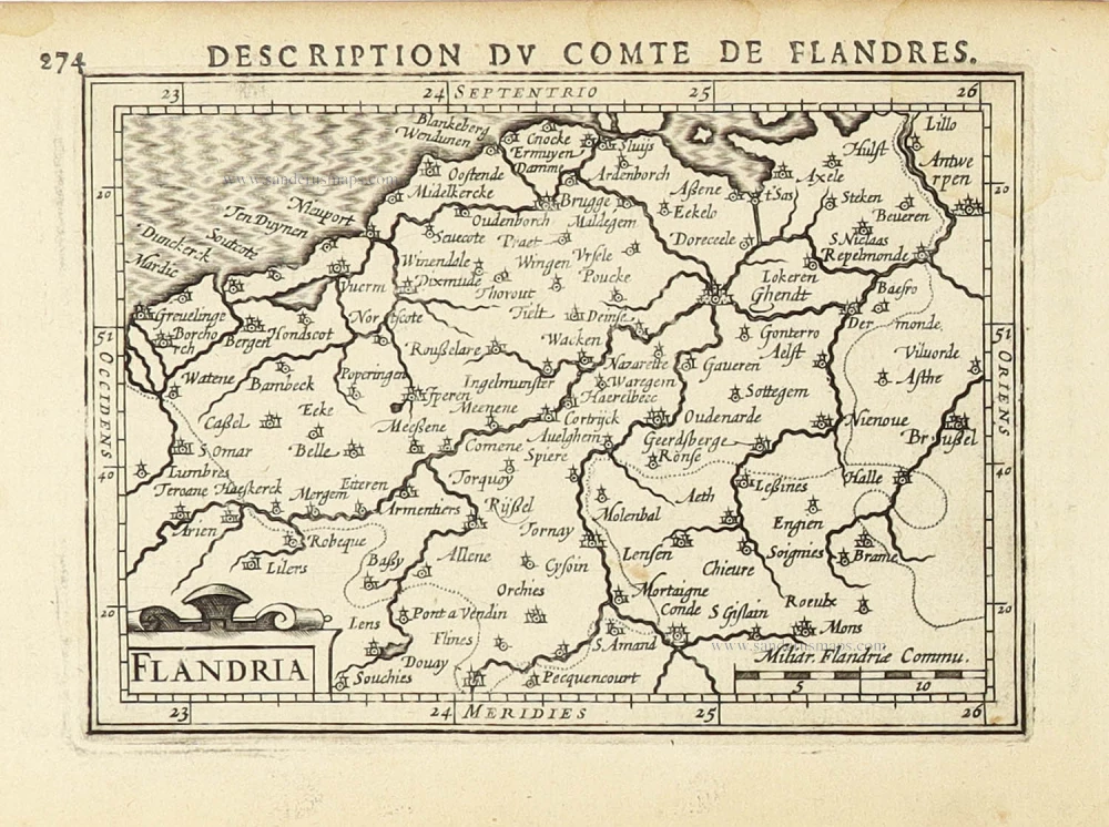
Western Flanders (West-Vlaanderen), by Henricus Hondius. 1638
Flandriae Pars Occidentalis continens ...
[Item number: 32445]

Western Flanders (West Vlaanderen), by Willem & Joan Blaeu. 1643
Pars Flandriae Teutonicae Occidentalior.
[Item number: 29934]

Western Flanders (West Vlaanderen) by N. Visscher II. 1683-1696
Flandriae Comitatus Pars Septentrionalis, comprehendens...
[Item number: 13092]
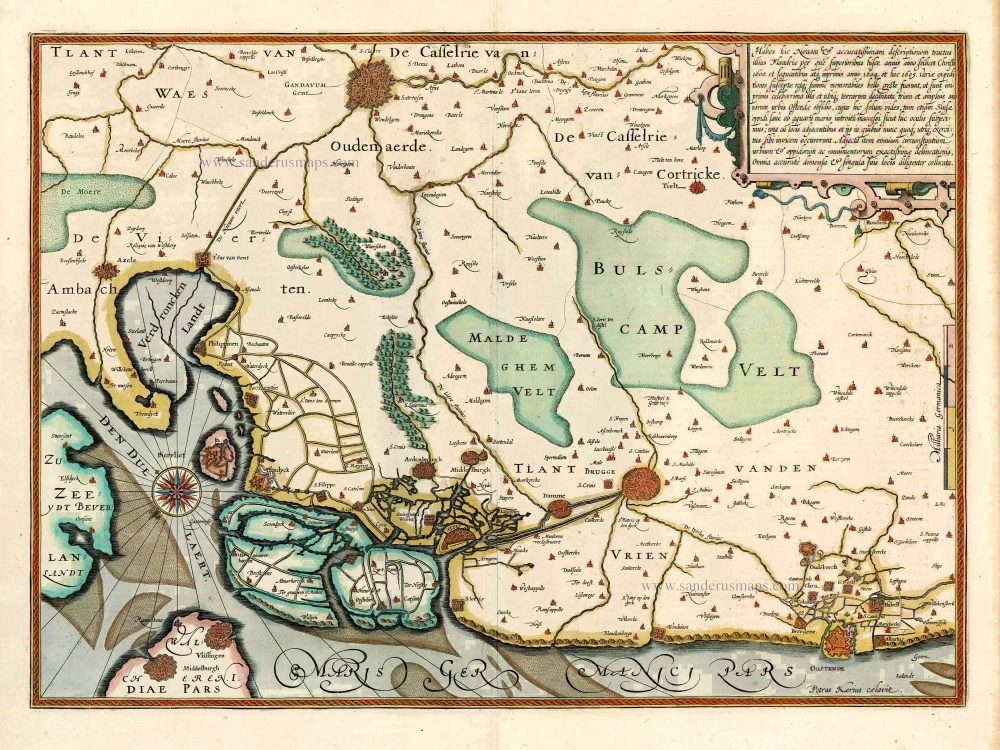
Western Flanders (West Vlaanderen) by Jodocus Hondius. 1619
Habes hic Novam & accuratissimam descriptionem tractus illius...
[Item number: 27325]

West Flanders, by Vincenzo Coronelli. 1696
Fiandra Parte Occidentale,
[Item number: 29223]

EXTREMELY RARE FLANDERS MAP BY PIETER VERBIEST
Vlaanderen (Flanders), by Pieter Verbiest. 1630
Comitatus Flandria.
[Item number: 28002]
Vlaanderen (Flanders) by Petrus Bertius, published by Jodocus Hondius II. 1618
Flandria.
[Item number: 31592]
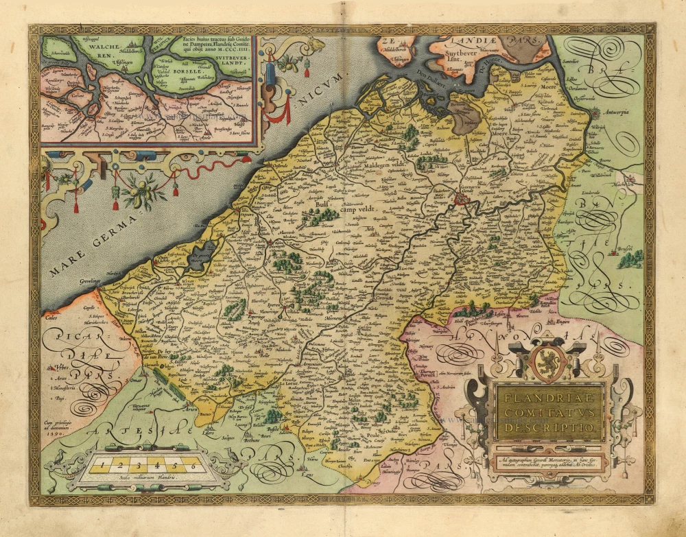
Vlaanderen by Abraham Ortelius 1601
Flandriae Comitatus Descriptio.
[Item number: 5767]

Vier Ambachten by Sanderus A. 1644
Kaerte Van De Vier Ambachten.
[Item number: 25277]

The vicinity of Oudenaarde, by Pieter Husson. c. 1709
Plan du Champ de Bataille, prés d'Oudenaerde l'11. Juillet 1708....
[Item number: 27525]
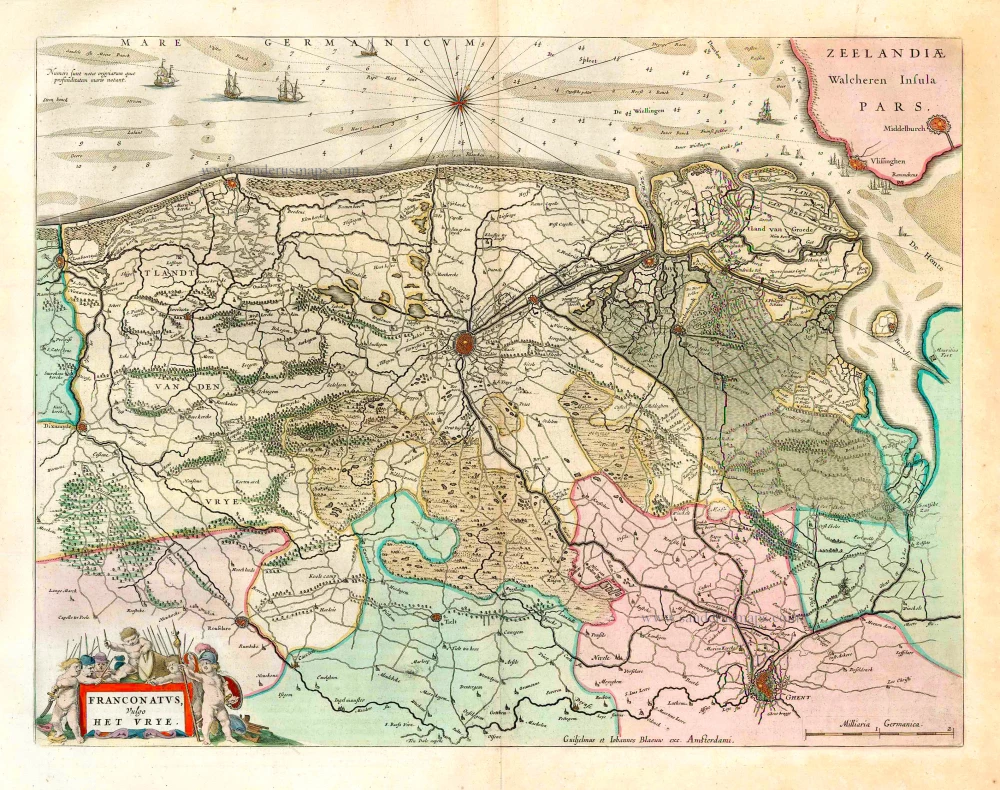
The vicinity of Bruges, by W. & J. Blaeu. 1662
Franconatus Vulgo Het Vrye.
[Item number: 26029]
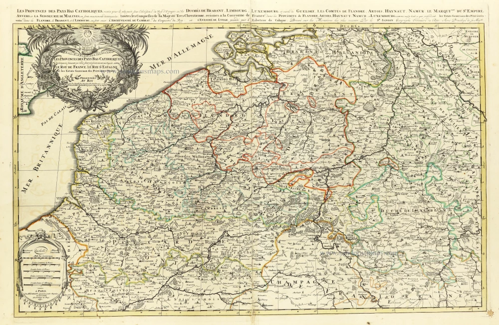
The Southern Netherlands, by N. Sanson, so-called published by Hubert Jaillot. (Pirated edition by Pierre Mortier). 1692
Les provinces des Pays Bas Catholiques distinguées suivant...
[Item number: 31720]

The Fleet Landing at Philippine in 1600. 1619
Classis bis mille & octingentarum navium omnibus belli copijs...
[Item number: 29332]

The Duchy of Brabant by Pieter van den Keere (Petrus Kaerius). 1617
Brabantia Ducatus Machliniae Urbis Dominium.
[Item number: 28672]

Rare first state
The bishopric of Ypres (Ieper), by Antonius Sanderus, published by Henricus Hondius. 1641-1644
Iprensis Episcopatus.
[Item number: 32850]

The bishopric of Bruges (Brugge), by Antonius Sanderus. 1641-1644
Episcopatus Brugensis.
[Item number: 32567]

The bishopric of Bruges (Brugge), by Antonius Sanderus, published by Joan Blaeu. 1659-72
Episcopatus Brugensis.
[Item number: 23881]
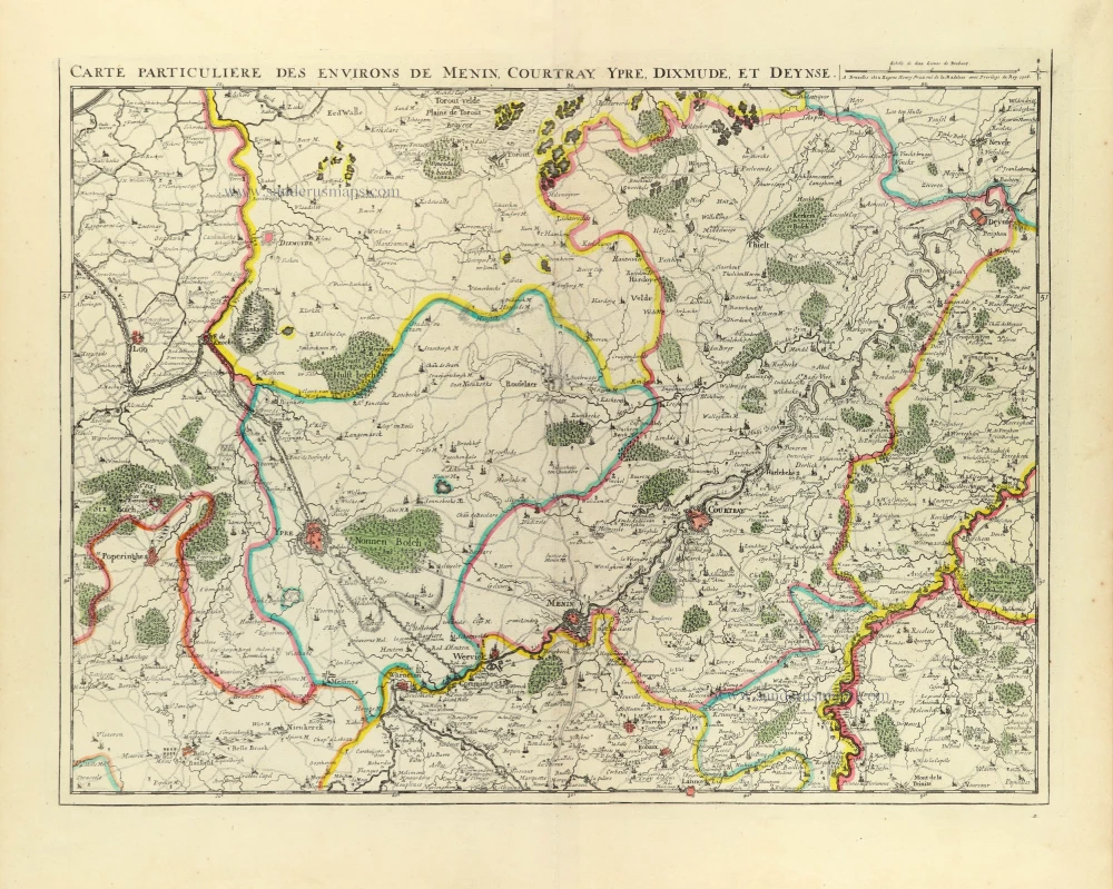
Southern West-Vlaanderen by E.H. Fricx. 1712
Carte Particulière des environs de Menin, Courtray, Ypre,...
[Item number: 32594]

Southern Netherlands, by Petrus Schenk. c. 1730-1760
Europae (Ae) Bellonae Theatrum Magnum et Fere Perpetuum...
[Item number: 28008]
Rare first state
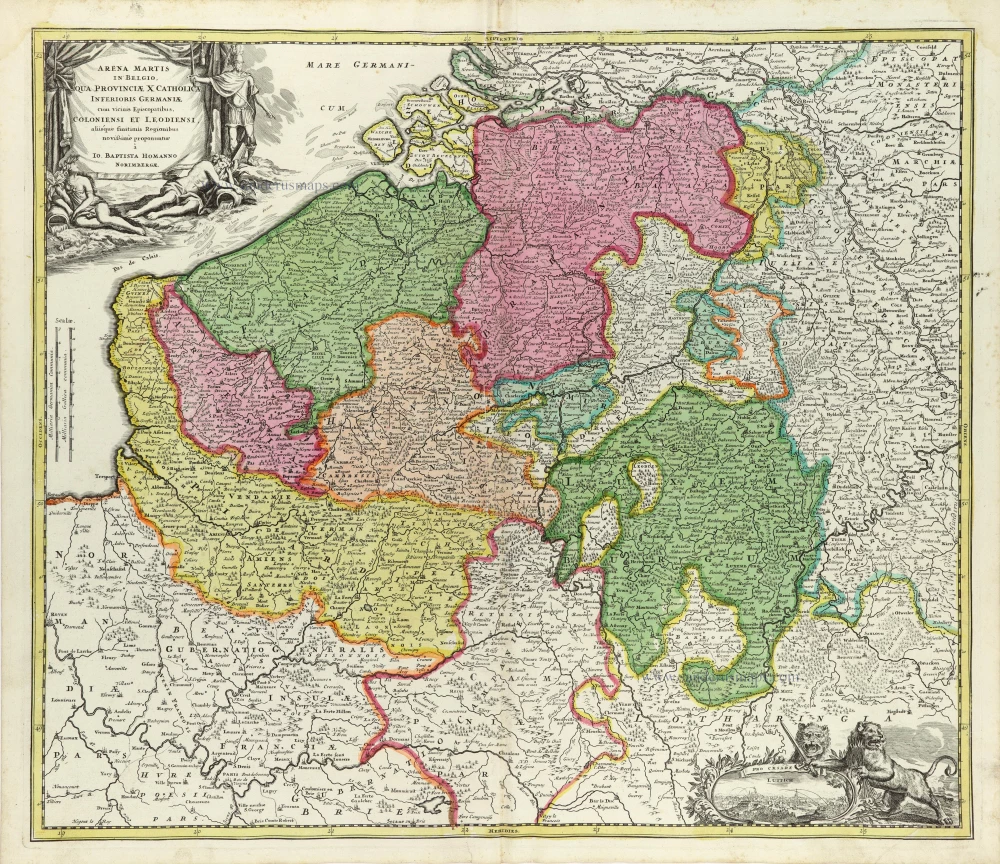
Southern Netherlands, by J.B. Homann. 1707
Arena Martis in Belgio, qua Provinciae X Catholica Inferioris...
[Item number: 32465]
![Carte des Pays Bas Catholiques. [Title above map:] Belgium Regium Accuratissime divisum. &c. ad usum serenissimi Burgundiae Ducis. Aythore G. De L'Isle, Geographe.](https://sanderusmaps.com/assets/IMG/webp/m28338.webp)
Southern Netherlands by G. De L'Isle, published by Covens & Mortier. ca. 1730.
Carte des Pays Bas Catholiques. [Title above map:] Belgium...
[Item number: 28338]

Southern Netherlands (Zuidelijke Nederlanden) by Nicolas Sanson, published by Giovanni Giacomo de Rossi. 1677
Provincie Meridionali de Paesi Bassi, Intese sotto nome di...
[Item number: 32903]
new

Southern Netherlands (Zuidelijke Nederlanden) by Nicolaes Visscher I. c. 1678
Belgii Regii accuratissima Tabula.
[Item number: 28518]

Southern Brabant par Robert de Vaugondy. 1757
Partie Septentrionale du Duché de Brabant où se trouvent les...
[Item number: 30403]
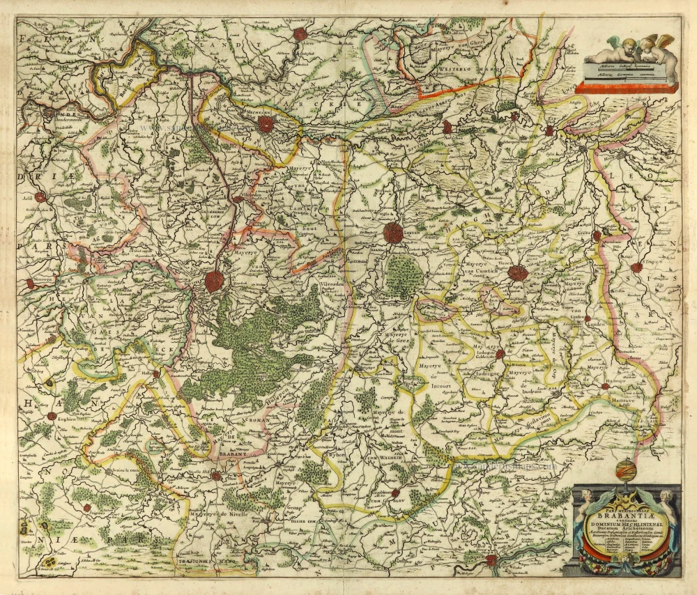
Southern Brabant by Henricus Hondius. 1641
Pars Meridionalis Brabantiae continens Dominium Mechliniense...
[Item number: 26303]

Forêt de Soignes - Zoniën Woud by Willem Blaeu.
Southern Brabant (Brussels) by Willem Blaeu. 1643
Secunda Pars Brabantiae cuius urbs primaria Bruxellae.
[Item number: 29930]

Southeast England with the adjacent coastline of France and Belgium, by Nicolas Sanson. 1658
Anciens royaumes de Kent, d'Essex, et de Sussex ou sont...
[Item number: 29627]

Sea chart of Flanders (Vlaanderen) & Zeeland, by Pieter Goos. 1667
Paskaert van de Zeeusche en Vlaemsche Kusten, tonende Alle...
[Item number: 19054]

Rare sea chart of the Netherlands.
Willem Blaeu, pirate edition by Joannes Janssonius. 1620-1634
Pascaarte van Hollandt Zeelandt ende Vlaanderen, van Texel af...
[Item number: 30058]
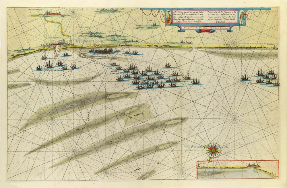
Roadstead of Dunkerque by Blaeu W. & J. 1647-50
Afbeeldinge vande vermaerde seehaven ende stadt van Duynkercken...
[Item number: 13895]

Oudenaarde by Eugène Fricx. 1712
Plan de la Bataille d'Oudenaerde du 11 Juillet 1708.
[Item number: 29585]
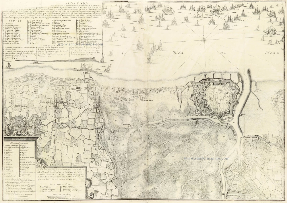
Oostende by Eugène Fricx. 1712
Plan de la ville d'Ostende
[Item number: 30792]
Rare Visscher map of Het Zwin, in a stunning colouring and gold-heightened, all in the style of Dirk Van Santen
Oost-Vrije (West Zeeuws-Vlaanderen), by Nicolaes Visscher. 1656
't Meerderdeel van 't OOST-VRYE in Vlaenderen Vertonende...
[Item number: 32588]

Extremely rare Verbiest map of Land van Waes
Oost-Vlaanderen - Land van Waes by Pieter Verbiest. 1656
Caerte figuerative van t'Lant van Waes ende Hulster Ambacht als...
[Item number: 31253]

Rare.
The vicinity of Veurne, by Joan Blaeu. 1664-65
Castellania Furnensis.
[Item number: 27083]