Antique maps catalogue
- All recent additions
-
Antique maps
- Polar maps
- World
-
Europe
- Europe Continent
- Belgium
- Belgium - Cities
- The Low Countries
- The Netherlands
- The Netherlands - Cities
- Luxembourg
- France
- France - Cities
- Germany
- Germany - Cities
- Austria
- Italy
- Italy - Cities
- Spain and Portugal
- Greece & Greek Islands
- Switzerland
- British Isles
- British Isles - Cities
- Northern Europe
- Central Europe
- Eastern Europe
- Southeastern Europe
- America
- Asia
- Africa
- Mediterranean Sea
- Australia
- Oceans
- Celestial Maps
- Curiosities
- Title Pages
- Books
- Medieval manuscripts
- Prints
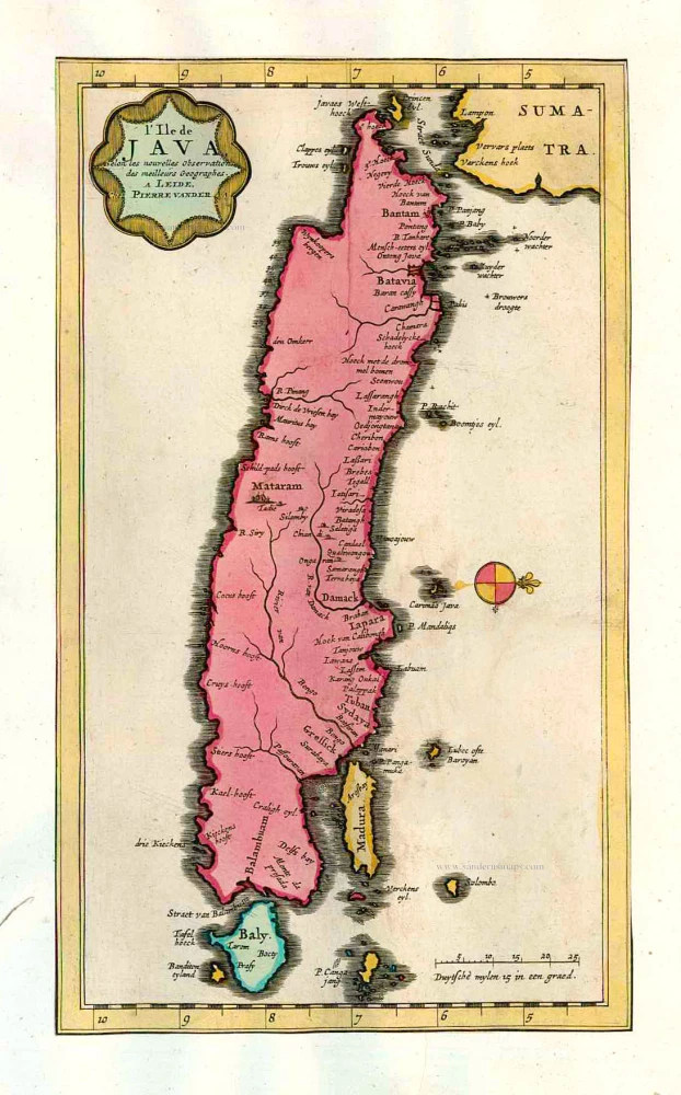
Java, by Pieter van der Aa. 1713
L'Ile de Java.
[Item number: 26127]

Java, by Z. Châtelain. 1719
Carte de L'Ile de Java: Partie Occidentale, Partie Orientale,...
[Item number: 29377]

Malacca by Barent Langenes & Cornelis Claesz c. 1600
Malacca.
[Item number: 26934]

Malacca by Petrus Bertius, published by Jodocus Hondius II. 1618
Malacca.
[Item number: 32150]

Malacca, by François Valentyn. 1726
De Stad Malacka.
[Item number: 27898]

Malaysia - Sumatra by François Valentyn (Valentijn) 1724-26
Nieuwe Kaart van het Eyland Sumatra.
[Item number: 26898]
Scarce
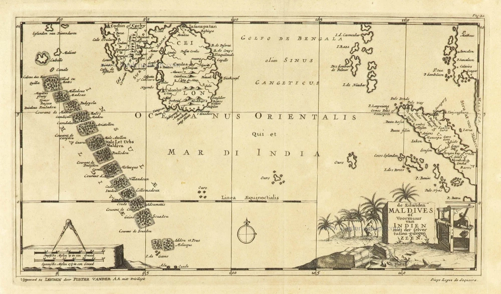
Maldives and Ceylon, by Pieter Van der Aa. 1707
De Eilanden Maldives of Voormuur van Indien met der selver...
[Item number: 32342]

Manilla Bay, par Pieter van der Aa. 1719
La Baie de Manille.
[Item number: 28115]

Early and important view of Manilla Bay
Manilla, by J.L. Gottfried. 1631
Manila.
[Item number: 31564]

Rare
Philippines, travel book by Ramon Gonzalez Fernandez & Federico Moreno y Jeréz 1875
Manual del viajero en Filipinas.
[Item number: 32605]
![[No title]](https://sanderusmaps.com/assets/IMG/webp/m20926.webp)
Moluccas - Buru and Ambelou, by Valentyn. 1724-26
[No title]
[Item number: 20926]

Moluccas by Barent Langenes & Cornelis Claesz c. 1600
Moluccae Insulae.
[Item number: 26996]

Spice islands
Moluccas by Joannes Janssonius. 1646
Insularum Moluccarum Nova Descriptio.
[Item number: 23718]

The Spice Islands
Moluccas by Willem Blaeu 1640
Moluccae Insulae Celeberimae.
[Item number: 31047]

Moluccas, by Petrus Bertius 1618
Moluccae insulae.
[Item number: 32174]

Scarce
Moluccas, by Pieter Van der Aa. 1707
De Moluccos, of Speceri-dragende Eilanden Tussen Gigolo en...
[Item number: 32346]
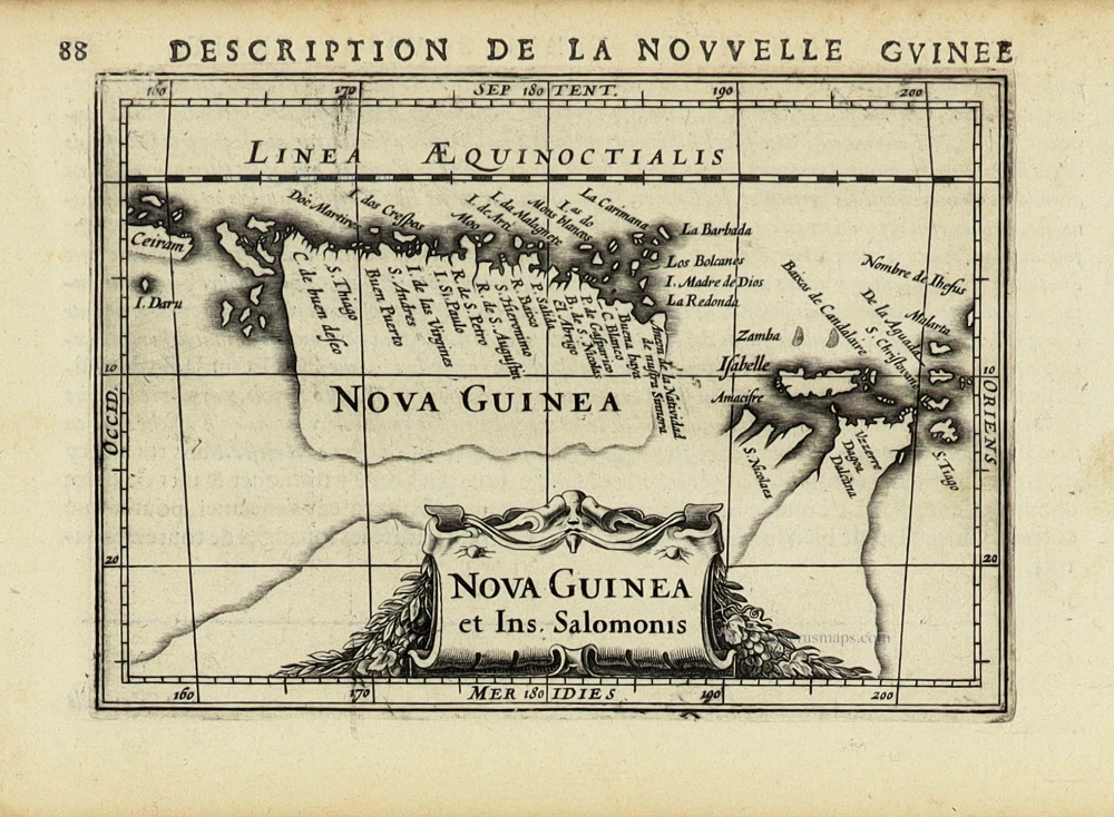
New Guinea by Petrus Bertius, published by Jodocus Hondius II. 1618
Nova Guinea et Ins. Salomonis.
[Item number: 31528]
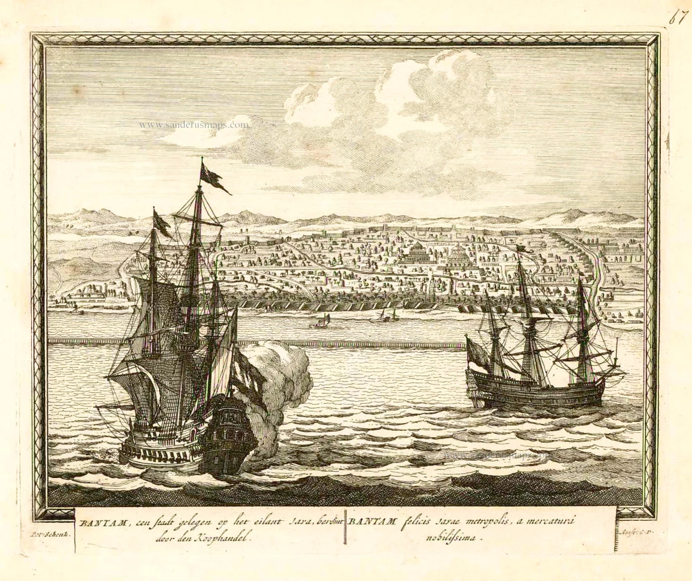
Banten (Bantam - Indonesia), by Petrus Schenk. 1702
Bantam, een stadt gelegen op het eilant Java, beroemt door den...
[Item number: 26661]

Borneo, by J. Janssonius. 1657-62
Insula Borneo et occidentalis pars Celebis cum adjacentibus...
[Item number: 26456]

Big and important map.
Java, by François Valentyn (Valentijn). 1724-26
Nieuwe en zeer naaukeurige kaart van t Eyland Java Major of...
[Item number: 27054]

Southeast Asia, by Francesco Santini. 1776-79
Archipel des Indes Orientales qui comprend les Isles de la...
[Item number: 26977]

From the Cloppenburg edition
Southeast Asia, by G. Mercator - J. Hondius. 1630
Insulae Indiae Orientalis.
[Item number: 25234]

The most accurate and one of the most elegant 17th c. maps of the East Indies
Southeast Asia by Janssonius, Johannes 1644-58
Indiae Orientalis Nova Descriptio.
[Item number: 10013]

Southeast Asia, by J. Ottens. c. 1700
Le Royaume de Siam avec les Royaumes qui luy sont Tributaires,...
[Item number: 25716]
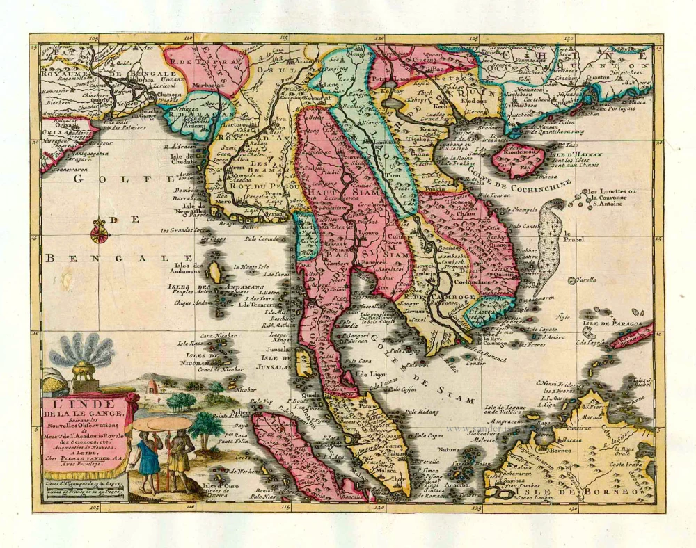
Southeast Asia, by Pieter van der Aa. 1713
L'Inde de la le Gange,
[Item number: 26097]

Southeast Asia, by Giovanni Magini. 1597
India Orientalis.
[Item number: 26521]

Sumatra, by G.B. Ramusio. 1563
Sumatra.
[Item number: 26313]
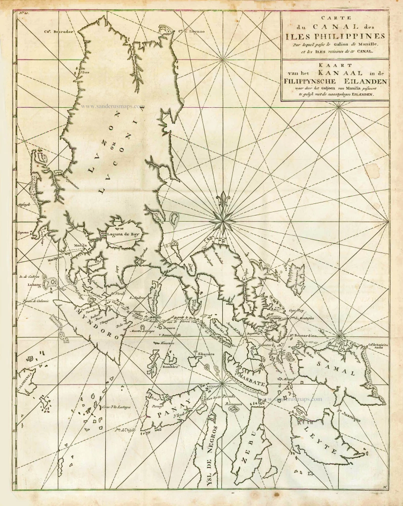
The Philippines, by George Anson. 1748
Carte du Canal des Iles Philippines par lequel Passe le Galion...
[Item number: 27036]

Jakarta (Batavia), by Petrus Schenk 1702
Batavia, gelegen op het eiland Java, een beroemde volkplanting...
[Item number: 26660]

Lovek (Longvek - Camboia), by François Valentyn (Valentijn). 1724-26
Eauweck, Hoofd-Stad van Cambodia.
[Item number: 26891]

Borneo, by Langenes, published by P. Bertius. 1602
Borneo.
[Item number: 26540]

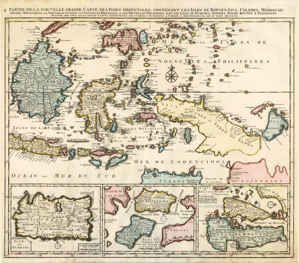
Indian Ocean (North), by J.B. Elwe. 1792
Partie de la Nouvelle Grande Carte des Indes Orientales,...
[Item number: 2363]
Indonesia - New Guinea - Australia by J.B. Elwe. 1792
Partie de la Nouvelle Grande Carte des Indes Orientales,...
[Item number: 2293]

The Banda Islands, by François Valentyn. 1724-26
Kaart der Zuyd-Wester Eylanden van Banda
[Item number: 17794]

View of Ternate (Moluccos) showing the eruption of the Gamalama volcano, by François Valentyn (Valentijn). 1724-26
Ternate.
[Item number: 26875]

Philippine Islands - Manila Bay by François Valentyn (Valentijn) 1724-26
Manilhas Bay.
[Item number: 27904]