Antique maps catalogue
- All recent additions
-
Antique maps
- Polar maps
- World
-
Europe
- Europe Continent
- Belgium
- Belgium - Cities
- The Low Countries
- The Netherlands
- The Netherlands - Cities
- Luxembourg
- France
- France - Cities
- Germany
- Germany - Cities
- Austria
- Italy
- Italy - Cities
- Spain and Portugal
- Greece & Greek Islands
- Switzerland
- British Isles
- British Isles - Cities
- Northern Europe
- Central Europe
- Eastern Europe
- Southeastern Europe
- America
- Asia
- Africa
- Mediterranean Sea
- Australia
- Oceans
- Celestial Maps
- Curiosities
- Title Pages
- Books
- Medieval manuscripts
- Prints

Philippines - Manila Strait by René Augustin Constantin de Renneville. 1725
Typus Freti Manilensis. - Détroit de Manilles.
[Item number: 28370]
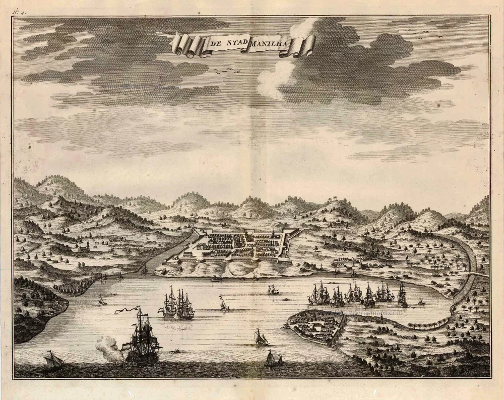
Philippines - Manilla by François Valentyn (Valentijn) 1726
De Stad Manilha.
[Item number: 27894]

Philippines by Bonne Rigobert 1749
Carte du Canal des Iles Philippines par lequel Passe le Galion...
[Item number: 26611]
Scarce and important map
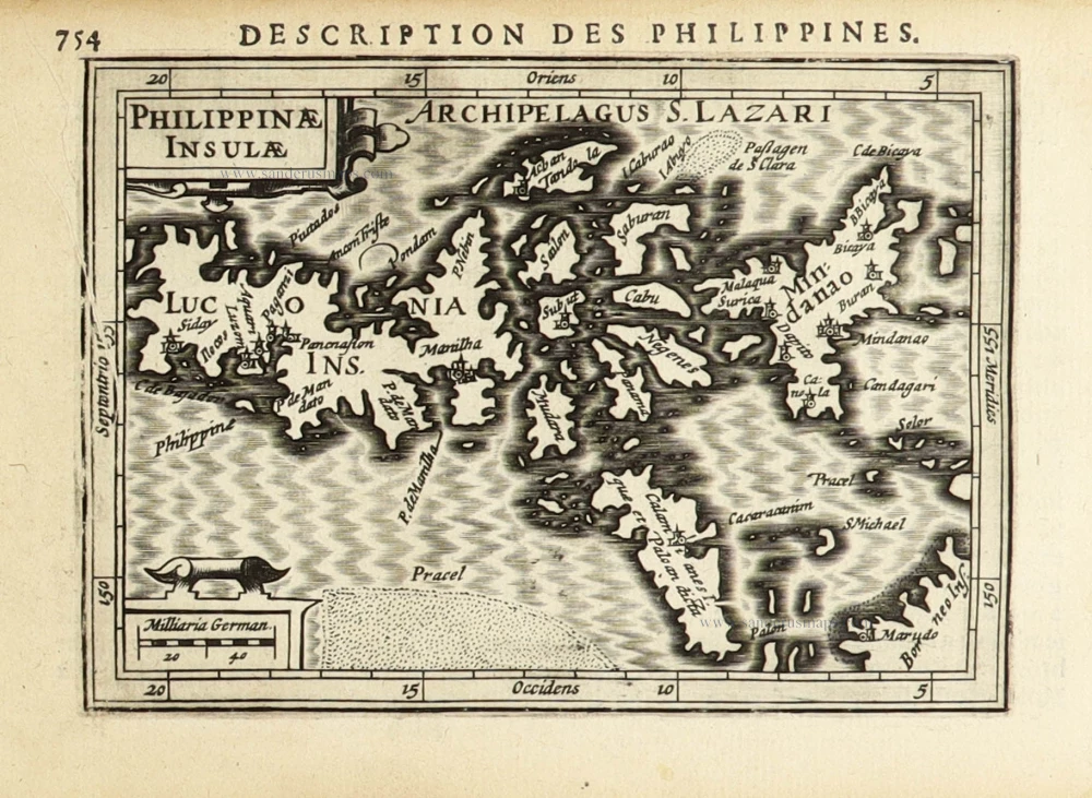
Philippines by Petrus Bertius. 1618
Philippinae Insulae.
[Item number: 32158]
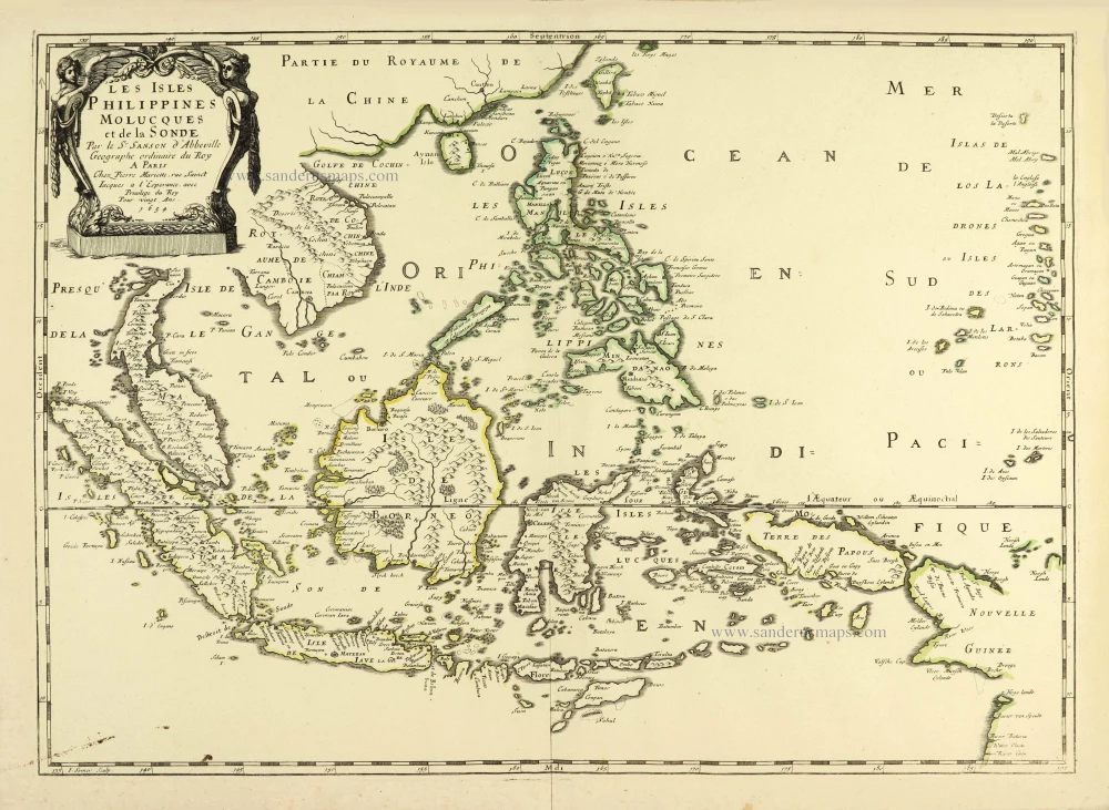
Southeast Asia par Nicolas Sanson. 1658
Les Isles Philippines Molucques et de la Sonde.
[Item number: 28378]

Philippines, by Valentyn François 1726
Lucon of Luconia.
[Item number: 27895]
![Les Isles Philippines [on sheet with] Islas de los Ladrones ou Isle des Larrons.](https://sanderusmaps.com/assets/IMG/webp/m30304.webp)
Philippines, by Nicolas Sanson, published by Prevost d'Exiles. 1747-74
Les Isles Philippines [on sheet with] Islas de los Ladrones ou...
[Item number: 30304]

Philippines, Moluccas, Borneo, and Sulawesi after J.N. Bellin, published by A.F. Prévost. 1747
Carte des Isles Philippines Celebes et Moluqes.
[Item number: 31881]
In rare original colour.
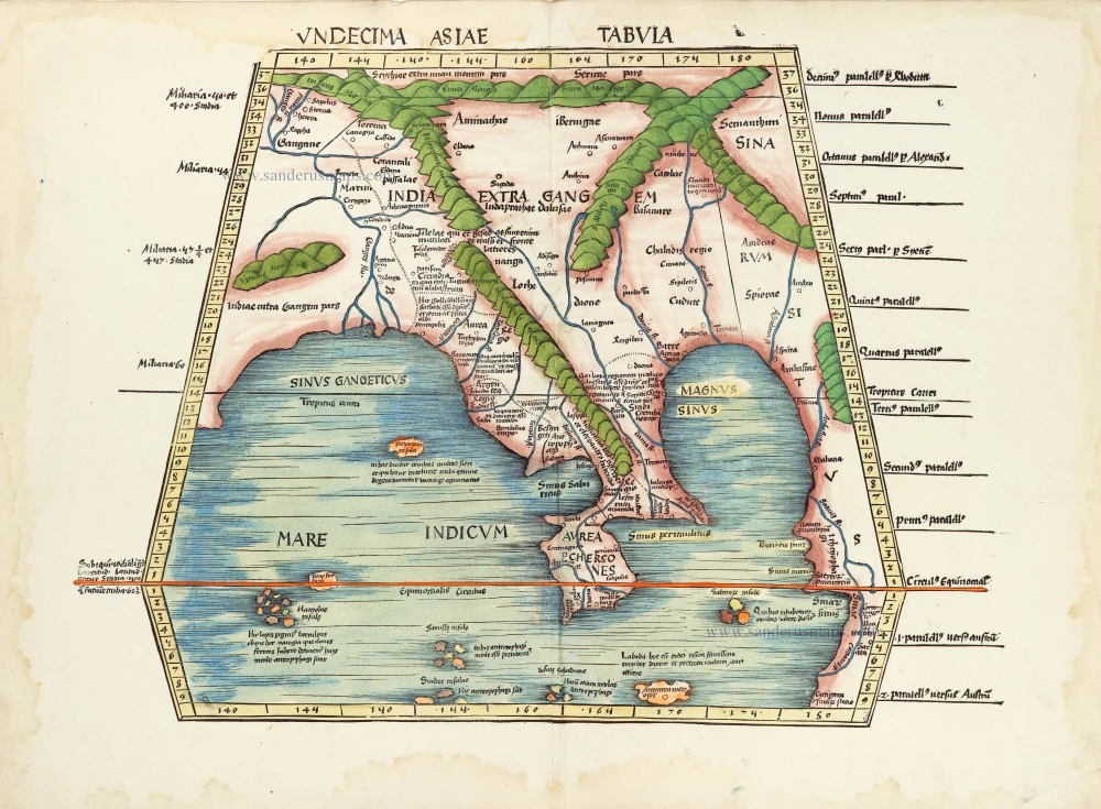
South Asia by Waldseemüller Martin 1513
Undecima Asiae Tabula.
[Item number: 29249]

Straits of Malacca, by Pieter van der Aa. 1713
Le Détroit de Malacca, Dressé sur les Memoires des plus Savans...
[Item number: 26105]
In rare original colour
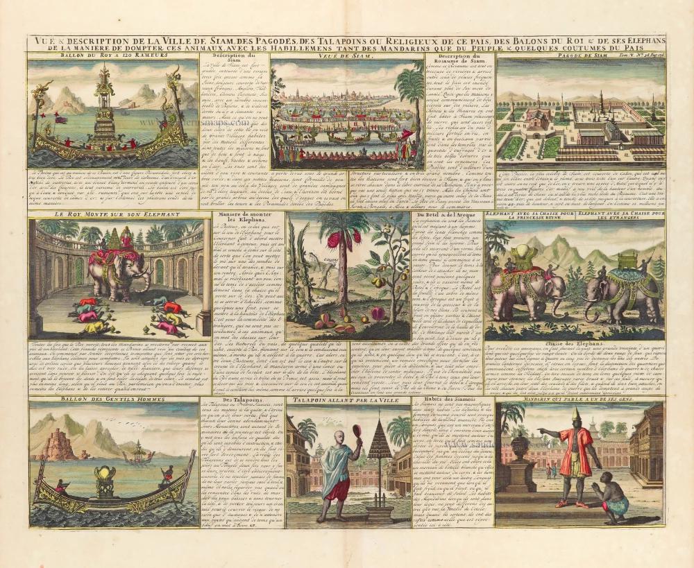
Set of 9 indigenous views of Thailand, by Z. Châtelain. 1719
Vue & Description de la ville de Siam, des Pagodes, des...
[Item number: 31558]

Southeast Asia - Australia by Frederick de Wit. c. 1691-97
Indiae Orientalis nec non Insularum Adiacentium.
[Item number: 29091]
![[No title] - 'Mar di India'.](https://sanderusmaps.com/assets/IMG/webp/m30057.webp)
Rare
East Indies by van Spilbergen Joris. 1645
[No title] - 'Mar di India'.
[Item number: 30057]
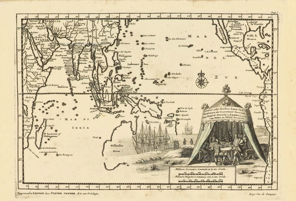
Southeast Asia and Australia, by Pieter Van der Aa. 1707
Indien onder den Heer Lopo Vaz de Sampayo, als Gouverneur...
[Item number: 32359]

Southeast Asia and Northwest Australia by Vincenzo Coronelli. 1696
Isole dell'Indie, Divise in Filippine, Molucche, e della Sonda.
[Item number: 28670]
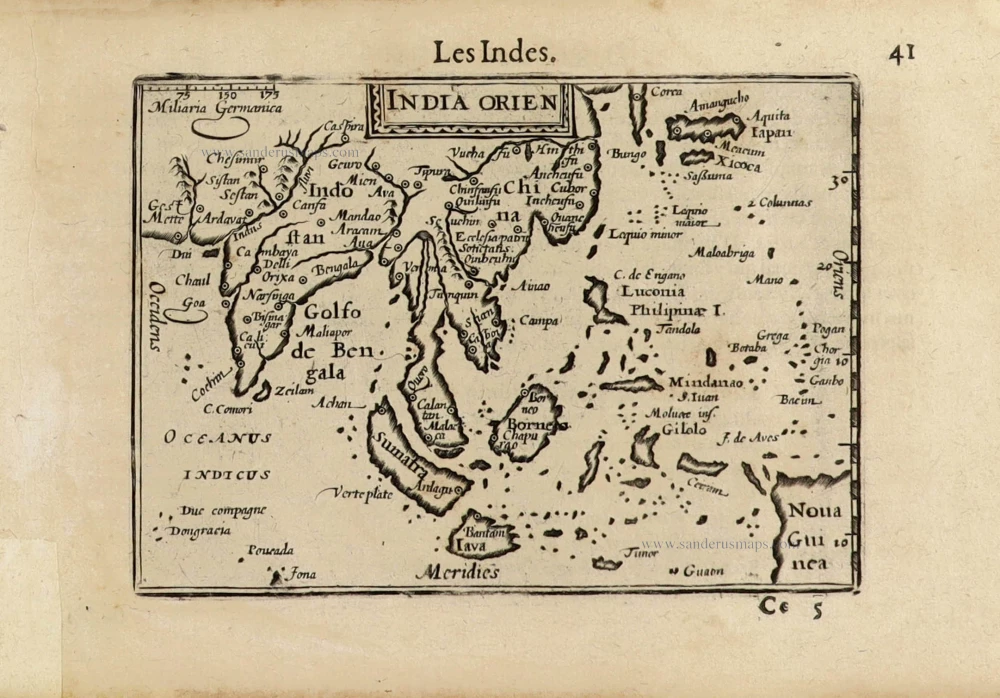
Southeast Asia by Barent Langenes. c. 1600
India Orien.
[Item number: 32298]

Scarce
Southeast Asia by Giacomo Gastaldi / Ptolemy. 1548
Tabula Asiae XI.
[Item number: 28362]
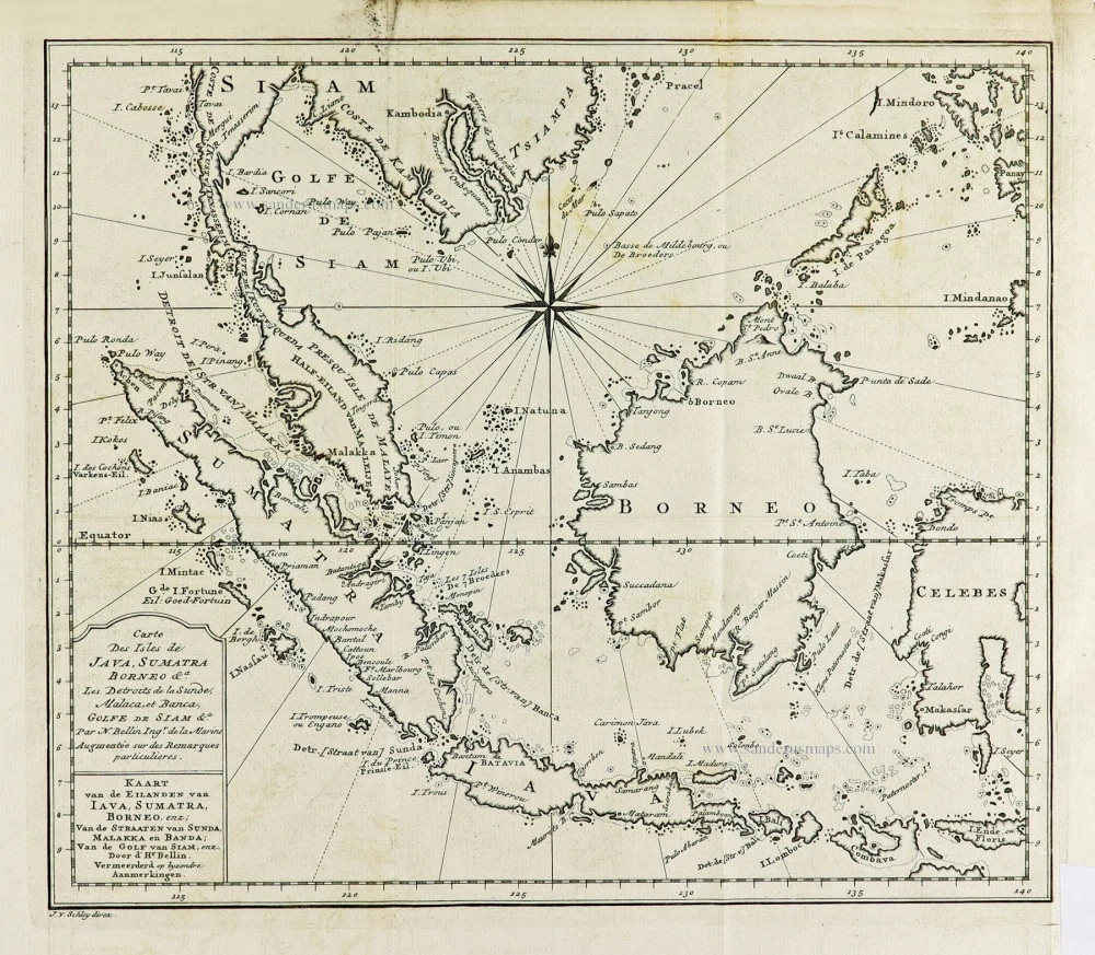
Southeast Asia by J.N. Bellin, published by A.F. Prévost. 1747
Carte Des Isles de Java, Sumatra, Borneo &a Les Detroits de la...
[Item number: 31882]

Southeast Asia by Jacques Nicolas Bellin. 1747
Suite de L'Ocean Oriental Contenant Les Isles de la Sonde Les...
[Item number: 28189]

Southeast Asia by Nicolaes Visscher I. 1678
Indiae Orientalis nec non Insularum Adiacentium Nova Descriptio.
[Item number: 28555]

Southeast Asia by Nicolaes Visscher, published by Petrus Schenk. c. 1740
Indiae Orientalis nec non Insularum Adiacentium Nova Descriptio.
[Item number: 25718]

Southeast Asia by Rigobert Bonne. 1690
Carte des Indes en deçà et au dela du Gange; avec les Isles de...
[Item number: 28304]
![Isole Molucche.- [Above map :] Descrittione del l'Isole Molucche.](https://sanderusmaps.com/assets/IMG/webp/m29788.webp)
Southeast Asia by Tommaso Porcacchi. 1590
Isole Molucche.- [Above map :] Descrittione del l'Isole Molucche.
[Item number: 29788]
This map has the first accurate depiction of the Philippines
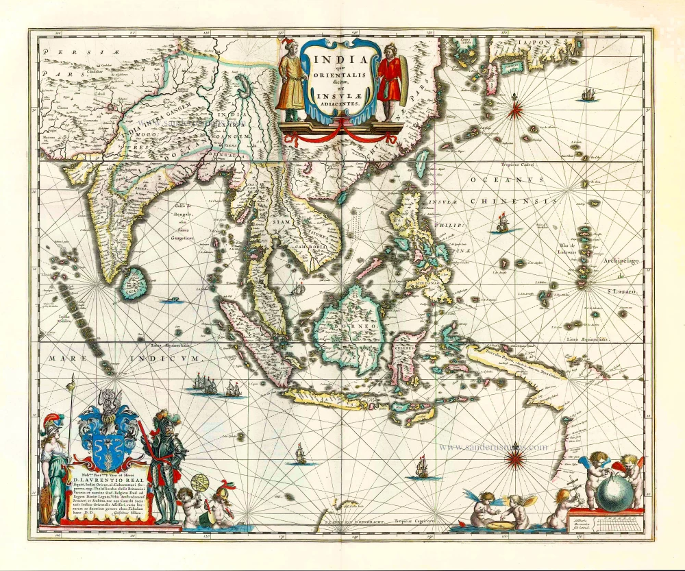
Southeast Asia by Willem & Joan Blaeu 1640-43
India quae Orientalis dicitur et Insulae Adiacentes.
[Item number: 26566]

Beautiful example of this important map
Southeast Asia, by Abraham Ortelius. 1587
Indiae Orientalis Insularumque Adiacientium Typus.
[Item number: 32831]

Very rare first 1570 A edition.
Southeast Asia, by Abraham Ortelius. 1570
Indiae Orientalis Insularumque Adiacientium Typus.
[Item number: 30592]

Southeast Asia, by Emanuel Bowen. 1747
A New and Accurate Map of the East India Islands.
[Item number: 28012]

Southeast Asia, by G. Mercator - J. Hondius (small) 1607
India Orientalis.
[Item number: 25186]

Southeast Asia, by J.B. d'Anville. 1746-53
Seconde Partie de la Carte d'Asie Contenant la Chine et Partie...
[Item number: 27401]
![[No title - on verso:] Tabula Moder. Indiae Orientalis.](https://sanderusmaps.com/assets/IMG/webp/m30658.webp)
Rare 1525 edition in nice old colour.
Ptolemy map of Southeast Asia by Lorenz Fries, after Martin Waldseemüller. 1525
[No title - on verso:] Tabula Moder. Indiae Orientalis.
[Item number: 30658]
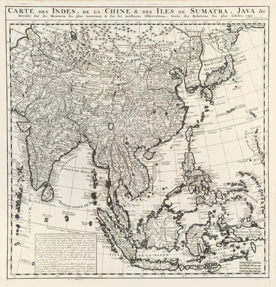
Southeast Asia, by Z. Châtelain. 1719
Carte des Indes, de la Chine & des Iles de Sumatra, Java &c.
[Item number: 29376]

Southeast Asia, par Robert de Vaugondy. c. 1757
Archipel des Indes Orientales qui Comprend les Isles de la...
[Item number: 4751]
![[No titel - from verso:] Tab. Moderna Indiae.](https://sanderusmaps.com/assets/IMG/webp/m30650.webp)
Rare 1525 edition in nice old colour.
Ptolemy map of southern Asia by Lorenz Fries, after Martin Waldseemüller. 1525
[No titel - from verso:] Tab. Moderna Indiae.
[Item number: 30650]
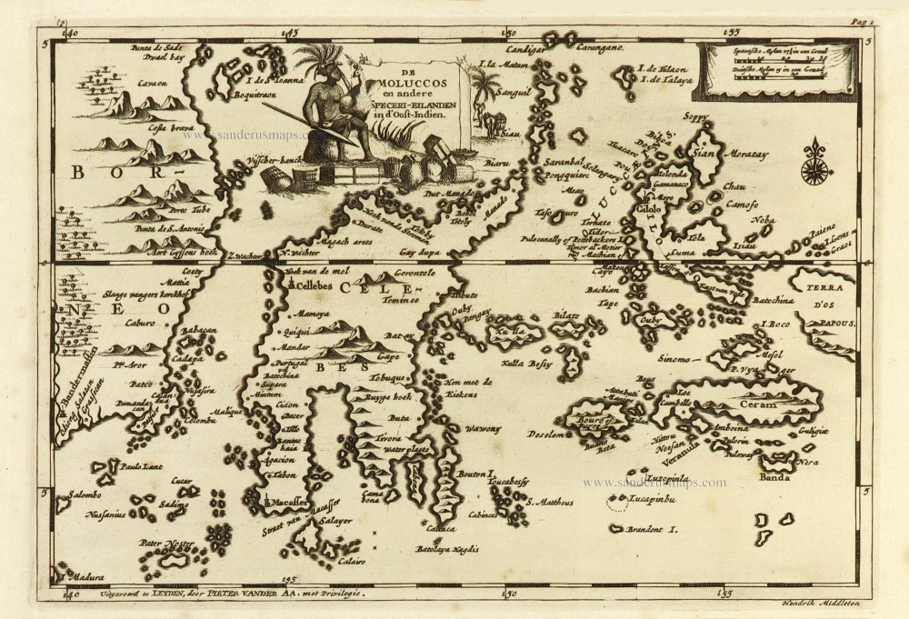
Spice Islands, by Pieter Van der Aa. 1707
De Moluccos en andere Speceri-eilanden in d'Oost-Indien.
[Item number: 32401]

Sumatra and the Malay Peninsula, by Sebastian Münster. 1588
Sumatra ein grosse Insel so von den alten Geographen Taprobana...
[Item number: 27586]

Sumatra by Barent Langenes & Cornelis Claesz c. 1600
Sumatra Insula.
[Item number: 26932]